As promised, the combination of cooler temperatures aloft coupled with an unstable, showery air mass, has resulted in substantial (several inches to a foot) of snow mainly above 4000ft. Compare the snow depth at 10 PM Sunday and Tuesday...quite an increase.


For the next 72 hr, residual snow showers will bring only modest amounts to the Cascades.
 The following 72 hr brings much more substantial snow to the north Cascades and mountains in BC.

Why so little over the more southern Cascades? The air will being getting much warmer as the persistent troughing over the northeast Pacific is reestablished.
The Climate Prediction Center's 6-10 day forecast (below) illustrates the problem--warmer than normal conditions over the Pacific Northwest and Rockies.

And the offshore troughing (low pressure) is illustrated by the upper level (500 hPa) for 7 PM on Friday evening. With a strong low offshore, strong southerly/southwesterly flow moves northward into our region bringing warmer air.

Now I am worried about the mountain snow pack this winter. We start with a weak La Nina that transitions into neutral conditions by early 2017. This would typically bring near normal snowpack over the Cascades.
But there is something else going on for the past month: the persistent troughing off the west coast and inland ridging, and the latest model runs suggest it will remain in place during the next few weeks. The higher elevation (about 4500 ft) and more northern areas (e.g., Whistler) might be salvaged, but the lower areas will have a problem developing a base.
My own rough rule of thumb is that when the temperature rises above 50F in Seattle, rain will invade the lower ski areas of our region. Keep that in mind the next few days.
___________________________________


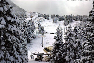
Cam shots Wednesday show Steven Pass and Paradise on Mt. Rainier looking quite wintery. Stevens got 9 inches today--a good start.


For the next 72 hr, residual snow showers will bring only modest amounts to the Cascades.


Why so little over the more southern Cascades? The air will being getting much warmer as the persistent troughing over the northeast Pacific is reestablished.
The Climate Prediction Center's 6-10 day forecast (below) illustrates the problem--warmer than normal conditions over the Pacific Northwest and Rockies.

And the offshore troughing (low pressure) is illustrated by the upper level (500 hPa) for 7 PM on Friday evening. With a strong low offshore, strong southerly/southwesterly flow moves northward into our region bringing warmer air.

Now I am worried about the mountain snow pack this winter. We start with a weak La Nina that transitions into neutral conditions by early 2017. This would typically bring near normal snowpack over the Cascades.
But there is something else going on for the past month: the persistent troughing off the west coast and inland ridging, and the latest model runs suggest it will remain in place during the next few weeks. The higher elevation (about 4500 ft) and more northern areas (e.g., Whistler) might be salvaged, but the lower areas will have a problem developing a base.
My own rough rule of thumb is that when the temperature rises above 50F in Seattle, rain will invade the lower ski areas of our region. Keep that in mind the next few days.
___________________________________
Announcement: Meeting of the Puget Sound Chapter of the American Meteorological Society at 10 AM Saturday Nov 19 at Seattle's Lake City Library.
As many of you know, a potentially historic wind storm was forecast to impact the Pacific Northwest on October 15th. Ultimately, the experienced winds were lower than predicted. Many wondered what went wrong--was it the forecasts, poor communication, or what? National Weather Service's Andy Haner, UW's Cliff Mass and KOMO's Scott Sistek will be presenting about the ides of October Storm windstorm. In addition, we will have discussions about future meetings, general elections and, of course, refreshments! Anyone interested in weather is invited.
Getting to the Library:
http://www.spl.org/locations/lake-city-branch/lcy-getting-to-the-branch
Post a Comment