Mount Baker Ski area, located in the northern Washington Cascades (see map below), is a fabled

location for large amounts of snow. For example, it holds the U.S. record for annual snowfall (1140 inches).

And today, the Mount Baker Ski Area website is claiming that they have more snow than any other ski facility in the entire U.S.! With 83 inches at 5000 ft!

Are these Trumparian claims? Is Mount Baker really that snow bound? And if so, why are they so endowed with the white stuff?
A glance at the snow depth analysis from the NOAA National Hydrological Center shows that the greatest snow depths (darker blues and purples) today are clearly over our part of the country,
 A closer view shows heaviest snow around the volcanic peaks, the north Cascades and the Olympics.
The Hurricane Ridge ski area in the Olympics is not open yet, so I think that the Mount Baker ski area has reason to crow that they are tops in the U.S. right now. And the all-time record was pronounced by an official arm of the U.S. government, so I am certainly not in a position to dispute their findings.

So what is it about Mount Baker ski area that gives it so much snow? It is really not that high, with most of the ski runs between 4000 and 5000 ft. Folks in Colorado or the Sierra would laugh at such low elevations.
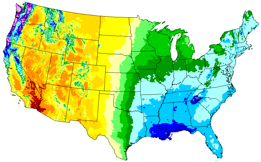
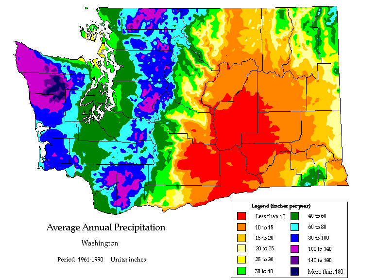
But Mount Baker and much of the Cascades start with a big advantage: lots of moisture and precipitation. The western slopes and crests of the Northwest mountains are the wettest locations in the U.S. due to the persistent winter storms passing over the region in winter and the great enhancement by the regional terrain (see annual climatological precipitation maps below).


The north Cascades are not as wet as the western side of the Olympics, but are far enough to the northeast of the Olympics that they escape much of the Olympic rain shadow. Furthermore, the terrain around Mount Baker extends more westward than the bulk of the nearby Cascades and has more of a NW-SE orientation, providing more uplift to the frequent southerly/southwesterly flow of the region.
Thus, with many incoming storms and moist air off the Pacific moving up the terrain (and thus cooling, saturating, and then precipitating), moisture is no problem. The best supply in the U.S.
And there is not much high terrain upstream of Baker for the typical southwesterly winter flow; there there is less competition for the incoming moisture.
But then there is the issue of temperature...the air must be cold enough to snow. That average freezing level (or melting level) of the air coming into our region (as observed at the Quillayute radiosonde site) is shown by the graphic below (from the wonderful NOAA/NWS Storm Prediction Center website). On average, the freezing level is near 4000 ft. And keep in mind that snow does not melt immediately at freezing...the snow level (where all the snow is melted) is about 1000 ft below the freezing (or melting) level.

So Baker is just high enough to get reliable snow. And, of course, being in the northern part of Cascades makes it cooler than, say, central Oregon.
But there is something else. The amount of snow is enhanced for temperatures just below freezing, because the amount of moisture that air can hold (and thus precipitate) is greatest for warmest temperatures. You can get heavier snowfalls in general for temperatures between 27 and 32F then 15 and 20F. So Baker is at the perfect altitude range for maximum snow. To put it another way, a ski are at 4000-5000 ft gets more snow than at 6000-7000 ft with an average 4000 ft freezing level.
Lots of moisture, great exposure to incoming flow, orographic/upslope precipitation enhancement, and perfect elevation range for the observed freezing level come to together for an optimum environment for lots of snow.
Finally, let's end this blog by looking at the snowfall and accumulation at the Baker observing site maintained by the Northwest Avalanche Center. The top figure shows 24h snowfall and the bottom, snow depth. About 65 inches at Baker, with the big dumps on Nov 24th and 25th.

More is coming.
location for large amounts of snow. For example, it holds the U.S. record for annual snowfall (1140 inches).
And today, the Mount Baker Ski Area website is claiming that they have more snow than any other ski facility in the entire U.S.! With 83 inches at 5000 ft!

Are these Trumparian claims? Is Mount Baker really that snow bound? And if so, why are they so endowed with the white stuff?
A glance at the snow depth analysis from the NOAA National Hydrological Center shows that the greatest snow depths (darker blues and purples) today are clearly over our part of the country,

The Hurricane Ridge ski area in the Olympics is not open yet, so I think that the Mount Baker ski area has reason to crow that they are tops in the U.S. right now. And the all-time record was pronounced by an official arm of the U.S. government, so I am certainly not in a position to dispute their findings.
So what is it about Mount Baker ski area that gives it so much snow? It is really not that high, with most of the ski runs between 4000 and 5000 ft. Folks in Colorado or the Sierra would laugh at such low elevations.
But Mount Baker and much of the Cascades start with a big advantage: lots of moisture and precipitation. The western slopes and crests of the Northwest mountains are the wettest locations in the U.S. due to the persistent winter storms passing over the region in winter and the great enhancement by the regional terrain (see annual climatological precipitation maps below).
The north Cascades are not as wet as the western side of the Olympics, but are far enough to the northeast of the Olympics that they escape much of the Olympic rain shadow. Furthermore, the terrain around Mount Baker extends more westward than the bulk of the nearby Cascades and has more of a NW-SE orientation, providing more uplift to the frequent southerly/southwesterly flow of the region.
Thus, with many incoming storms and moist air off the Pacific moving up the terrain (and thus cooling, saturating, and then precipitating), moisture is no problem. The best supply in the U.S.
And there is not much high terrain upstream of Baker for the typical southwesterly winter flow; there there is less competition for the incoming moisture.
But then there is the issue of temperature...the air must be cold enough to snow. That average freezing level (or melting level) of the air coming into our region (as observed at the Quillayute radiosonde site) is shown by the graphic below (from the wonderful NOAA/NWS Storm Prediction Center website). On average, the freezing level is near 4000 ft. And keep in mind that snow does not melt immediately at freezing...the snow level (where all the snow is melted) is about 1000 ft below the freezing (or melting) level.
So Baker is just high enough to get reliable snow. And, of course, being in the northern part of Cascades makes it cooler than, say, central Oregon.
But there is something else. The amount of snow is enhanced for temperatures just below freezing, because the amount of moisture that air can hold (and thus precipitate) is greatest for warmest temperatures. You can get heavier snowfalls in general for temperatures between 27 and 32F then 15 and 20F. So Baker is at the perfect altitude range for maximum snow. To put it another way, a ski are at 4000-5000 ft gets more snow than at 6000-7000 ft with an average 4000 ft freezing level.
Lots of moisture, great exposure to incoming flow, orographic/upslope precipitation enhancement, and perfect elevation range for the observed freezing level come to together for an optimum environment for lots of snow.
Finally, let's end this blog by looking at the snowfall and accumulation at the Baker observing site maintained by the Northwest Avalanche Center. The top figure shows 24h snowfall and the bottom, snow depth. About 65 inches at Baker, with the big dumps on Nov 24th and 25th.
More is coming.
Post a Comment