You think it has been colder than normal? It has been. But even colder air will descend over the region by this weekend, dropping temperatures below 20F for a number of western Washington locations. And lots of below-zero temperatures east of the Cascade crest.
We are talking about the coldest temperatures in 3-5 years for many locations. A hard freeze capable of damaging plants and freezing some exposed pipes.
And then there will be snow tomorrow over Oregon, the southern Cascades, southwest Washington, and much of eastern Washington.
Let's "warm up" by starting with the low temperatures on Tuesday (below). Upper 20s and 30s over western Washington, teens in the mountains, and single digits of NE Washington. A few negative temperatures in some cold pockets, generally in valleys. Before long you will be thinking of these temperatures as subtropical.

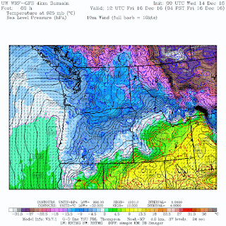
One way to show you the changes are with forecast maps of sea level pressure (solid lines) and 925 hPa (around 2500 ft) temperatures (colors). Blues are very cold and purples you don't want to know about.
Currently, cold air is found east of the Cascade crest with cool air over NW Washington.
 By Friday morning at 4 AM, the air has cooled and extended over all of Oregon.
 Four AM on Saturday, the entire region is locked in the ice box, with very cold air pushing into CA and Nevada.
 The latest European Center ensemble and high resolution temperature forecasts suggest the HIGHS at Sea Tac airport will remain in the upper 20s on Saturday and the lows in the lower 20s.


Sea-Tac is NOT a cold spot and teens will be prevalent away from the water and particularly in low-lying locations. Protect your pets, plants, and hoses.
And did a say something about snow? Yes, I did! A low pressure center will move across southern Oregon tomorrow, producing a shield of snow that will move across Oregon and SE Washington.
Here is the 24 h snow total ending 4 AM Thursday. Eastern Oregon really gets it, with the eastern slopes of the Oregon Cascades BURIED with several feet of snow. Folks around Mt. Batchelor will be smiling. Portland may get a small piece of this, as might Yakima and the Tri-Cities.
 But there is a bright light in all this. Expect plenty of sun with the cold temperatures and believe it or not, sunset times are now getting later. 4:17 PM today and by Monday it will be 4:19 PM. Unfortunately, it will still be getting darker in the morning until the winter solstice.
We are talking about the coldest temperatures in 3-5 years for many locations. A hard freeze capable of damaging plants and freezing some exposed pipes.
And then there will be snow tomorrow over Oregon, the southern Cascades, southwest Washington, and much of eastern Washington.
Let's "warm up" by starting with the low temperatures on Tuesday (below). Upper 20s and 30s over western Washington, teens in the mountains, and single digits of NE Washington. A few negative temperatures in some cold pockets, generally in valleys. Before long you will be thinking of these temperatures as subtropical.
One way to show you the changes are with forecast maps of sea level pressure (solid lines) and 925 hPa (around 2500 ft) temperatures (colors). Blues are very cold and purples you don't want to know about.
Currently, cold air is found east of the Cascade crest with cool air over NW Washington.


Weather.com, which uses sophisticated statistics on top of combining a number of major weather models, projects a high of 33 and a low of 21 on Friday.
And did a say something about snow? Yes, I did! A low pressure center will move across southern Oregon tomorrow, producing a shield of snow that will move across Oregon and SE Washington.
Here is the 24 h snow total ending 4 AM Thursday. Eastern Oregon really gets it, with the eastern slopes of the Oregon Cascades BURIED with several feet of snow. Folks around Mt. Batchelor will be smiling. Portland may get a small piece of this, as might Yakima and the Tri-Cities.

Post a Comment