I will have an Update at 1 PM Saturday-still looks like a light snow event after midnight... strong winds tomorrow over NW WA. And much colder. More later.
Confidence is high in a transition to much colder temperatures over the Northwest starting on Sunday, but what about lowland snow around Puget Sound?
Will there be snow flakes flying as folks return home from their New Year's celebrations early Sunday morning? Perhaps...but not too much.
The general situation for Saturday/Sunday is clear. As shown in the upper level map for 4 PM on Saturday, an upper level trough will move southward over the Northwest (with ridging over the Gulf of Alaska). The trough will provide upward motion that brings clouds and precipitation, and as it passes, cold arctic air from the continental interior will sweep south and west over our region.

By 1 AM Sunday morning, cold air (blue colors in surface chart below) will be moving into Washington State, with a trough of surface low pressure just south of Seattle.

At 10 AM Monday, very cold air has spread over the Northwest, with easterly flow pushing the frigid, arctic flow over the Pacific.

Although we will have both upward motion and cold air, the configuration above it not ideal for much snow. For substantial Puget Sound snow one wants the upper trough to extend farther offshore, with the associated surface low moving southward along the coast. That would both draw cold air southward and provide precipitation at the same time.
So what do the models show? The European Center ensemble (many model) snow total prediction for Seattle suggests only light snow, mainly after midnight--perhaps .5 to 1 inch. A much greater risk is suggested for next weekend (roughly 6 inches).
 The high-resolution European Center snow forecast through 4 AM Sunday shows light snow over the west (0-1 inches around Puget Sound near sea level, 1-2 inches near the Cascade foothills.

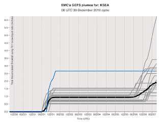
The National Weather Service (GEFS) ensemble forecasts shows a mean snow total around 1 inch by Sunday AM. This is snowfall, not snow depth.
So the bottom line in all this is that you should expect increasing clouds on Saturday as the trough approaches. Light rain will begin over the lowlands around dinner time and then transition to snow showers between 10 PM Saturday and 1 AM on Sunday. A few hours of light snow will follow before the atmosphere dries out on Sunday in the cold air. Much of the lowland snow will be focused on a Puget Sound Convergence Zone over north Seattle and the arctic front--the zone of transition to the cold, continental air. Most of the region will end up with little to perhaps an inch of snow. Not a big event, unless our forecasts are way off.

As noted earlier, the cold forecast for next week looks solid... the coldest period around here since December 2008. The latest European Center forecasts for high and low temperatures at Seattle suggest highs near freezing and lows in the mid to lower 20s for Monday through Thursday. Teens in cooler locations away from water.

Good time to remove exterior hoses, protect faucets, and block exterior vents. And keep pets inside.
Confidence is high in a transition to much colder temperatures over the Northwest starting on Sunday, but what about lowland snow around Puget Sound?
Will there be snow flakes flying as folks return home from their New Year's celebrations early Sunday morning? Perhaps...but not too much.
The general situation for Saturday/Sunday is clear. As shown in the upper level map for 4 PM on Saturday, an upper level trough will move southward over the Northwest (with ridging over the Gulf of Alaska). The trough will provide upward motion that brings clouds and precipitation, and as it passes, cold arctic air from the continental interior will sweep south and west over our region.

By 1 AM Sunday morning, cold air (blue colors in surface chart below) will be moving into Washington State, with a trough of surface low pressure just south of Seattle.

At 10 AM Monday, very cold air has spread over the Northwest, with easterly flow pushing the frigid, arctic flow over the Pacific.

Although we will have both upward motion and cold air, the configuration above it not ideal for much snow. For substantial Puget Sound snow one wants the upper trough to extend farther offshore, with the associated surface low moving southward along the coast. That would both draw cold air southward and provide precipitation at the same time.
So what do the models show? The European Center ensemble (many model) snow total prediction for Seattle suggests only light snow, mainly after midnight--perhaps .5 to 1 inch. A much greater risk is suggested for next weekend (roughly 6 inches).

The National Weather Service (GEFS) ensemble forecasts shows a mean snow total around 1 inch by Sunday AM. This is snowfall, not snow depth.
So the bottom line in all this is that you should expect increasing clouds on Saturday as the trough approaches. Light rain will begin over the lowlands around dinner time and then transition to snow showers between 10 PM Saturday and 1 AM on Sunday. A few hours of light snow will follow before the atmosphere dries out on Sunday in the cold air. Much of the lowland snow will be focused on a Puget Sound Convergence Zone over north Seattle and the arctic front--the zone of transition to the cold, continental air. Most of the region will end up with little to perhaps an inch of snow. Not a big event, unless our forecasts are way off.
As noted earlier, the cold forecast for next week looks solid... the coldest period around here since December 2008. The latest European Center forecasts for high and low temperatures at Seattle suggest highs near freezing and lows in the mid to lower 20s for Monday through Thursday. Teens in cooler locations away from water.

Good time to remove exterior hoses, protect faucets, and block exterior vents. And keep pets inside.
Post a Comment