Our region has endured one of the coldest periods in a few years, with teens west of the Cascade crest and single digits/below zero to the east. And now, some light snow is falling over NW Washington. But things are changing aloft, with warm air pushing in above us. Normal temperatures (40s) and rain are in the forecast.
The temperature traces over the past four weeks for Seattle and Pasco are enlightening...if not chilling (red and blue lines are average highs and lows, respectively). In Seattle, we have have been cooler than normal for the past two weeks, and the last few days were particularly frigid, with our high temperatures remaining below our normal lows.
 But if you want to be impressed, check out Pasco in the TriCities, where the recent temperatures have gyrated down to nearly -10F. That is cold.
 The origin of all our cold weather has been the combination of high pressure (ridging) offshore and low pressure (troughing), as illustrated by the upper level (500 hPa) map for Friday morning at 4 AM.
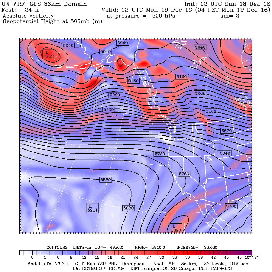
 The forecast map for 4 AM Monday is very different, with much more zonal (east-west flow) as a result of a weakened ridge/trough. Back to normal.

Over Seattle right now the temperatures aloft are warming rapidly (red lines, this figure show changes above Sea Tac with time--increasing to the left on the x axis and height on the y axis)
 The light snow is a sign of the warming, with the movement of warm air into the region associated with upward vertical motion. So far it has been mainly a dusting, as suggested by the latest cam shot near Bellingham.

What is going to happen now? The meteorologically enlightened prefer to use ensemble forecasts and a probabilistic viewpoint, so here are min and max temperatures forecast by the European Center model for Seattle. The range of possibilities is shown by the blue brackets. The ensembles are emphatic about a warm up (you can bet on that!), with highs reaching to near 48F in a few days. A slow cooling follows, but there is increasing uncertainty past a week. Enjoy the warmth...it will feel nearly tropical after what we had.

The Tri-Cities will have to wait a few days, as shown by the predicted temperatures at Hanford. But they will enjoy some thermal relief as well.

The temperature traces over the past four weeks for Seattle and Pasco are enlightening...if not chilling (red and blue lines are average highs and lows, respectively). In Seattle, we have have been cooler than normal for the past two weeks, and the last few days were particularly frigid, with our high temperatures remaining below our normal lows.


Over Seattle right now the temperatures aloft are warming rapidly (red lines, this figure show changes above Sea Tac with time--increasing to the left on the x axis and height on the y axis)


What is going to happen now? The meteorologically enlightened prefer to use ensemble forecasts and a probabilistic viewpoint, so here are min and max temperatures forecast by the European Center model for Seattle. The range of possibilities is shown by the blue brackets. The ensembles are emphatic about a warm up (you can bet on that!), with highs reaching to near 48F in a few days. A slow cooling follows, but there is increasing uncertainty past a week. Enjoy the warmth...it will feel nearly tropical after what we had.

The Tri-Cities will have to wait a few days, as shown by the predicted temperatures at Hanford. But they will enjoy some thermal relief as well.

Post a Comment