Today's high resolution imagery from the NASA MODIS satellite (below) shows a snowy region, since there are practically no clouds to obscure the view over most of the domain.

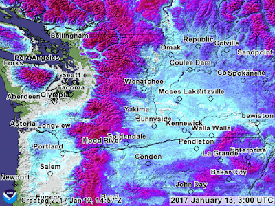
A NOAA snow depth analysis is found below (which is not perfect, but useful). Eastern Washington is completely snowed in and snow covers NE Oregon (except the immediate coast) and southwest Washington, as far north as Chehalis.


Obviously, this healthy snow pack, coupled with excellent reservoir levels bodes well for water resources and reduced fire potential during next summer.
A NOAA snow depth analysis is found below (which is not perfect, but useful). Eastern Washington is completely snowed in and snow covers NE Oregon (except the immediate coast) and southwest Washington, as far north as Chehalis.


With some strong winds in Grant County on Tuesday/Wednesday, the snow drifted--in some locations up to eight feet high. Here is an amazing image from the Grant County Sheriff's Office....more of a tunnel than a road.

With all the recent snow, the snowpack in Oregon is WAY above normal (see below), with much of the region with 130-140% percent of normal. Some of the coastal mountains over NW Oregon are 3900% of normal. Washington, other than the southern Cascades, is near normal.
Post a Comment