I have sad news for all of you.
La Nina is dead. Done. Finished. Terminated. The final word came out a week ago, provided by the august U.S. Climate Prediction Center (see below).

And it appear that we have a better than even chance of moving back into the El Nino pattern again, a configuration that leads to generally less snow over the Pacific Northwest.
To track the oscillation between La Nina, Neutral conditions, to El Nino and back again, meteorologists follow the sea surface temperatures (SST) in tropical Pacific. As I have noted in past blogs, this variation, also called El Nino Southern Oscillation (ENSO), represents a sloshing of the warm water in tropical Pacific. When the water sloshes towards the east we have El Nino, when it sloshes to the west, La Nina. You can think of the tropical Pacific as a giant bathtub.

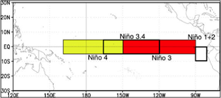
To get a handle on what the sloshing is up to, meteorologists follow the SSTs for a few areas in the tropical Pacific (the Nino 4, Nino 3.4, Nino 3 and Nino 1+2 areas). The figure below shows their locations.
The general approach is to track the SST anomalies (differences from normal) for these areas, with Nino 3.4 being probably the most popular. When Nino 3.4 has a warm anomaly greater than +.5C we have El Nino, an anomaly of -.5C or less, La Nina. Near zero, a neutral or La Nada period.
Here are the latest graphs of SST anomalies. Viewing the Nino 3.4 graph, you can see we had a weak La Nina for a while, but now temperatures are slightly on the warm side---we are in neutral conditions and probably have been for a few months.


The main U.S. seasonal model, CFSv2, is run as an ensemble (many forecasts). Although there is a lot of uncertainty, most runs are heading towards El Nino.


Let me stress that ENSO forecasts made mid-winter have been notoriously bad. Skill for the upcoming year increases substantially by summer.
One thing you can be sure about: with our reservoirs in decent shape and a near normal snowpack, the water situation in the NW looks excellent for this summer. And with California soaked this winter and its reservoirs filled, vegetable/fruit prices should be more modest than in past years.

La Nina is dead. Done. Finished. Terminated. The final word came out a week ago, provided by the august U.S. Climate Prediction Center (see below).
And it appear that we have a better than even chance of moving back into the El Nino pattern again, a configuration that leads to generally less snow over the Pacific Northwest.
To track the oscillation between La Nina, Neutral conditions, to El Nino and back again, meteorologists follow the sea surface temperatures (SST) in tropical Pacific. As I have noted in past blogs, this variation, also called El Nino Southern Oscillation (ENSO), represents a sloshing of the warm water in tropical Pacific. When the water sloshes towards the east we have El Nino, when it sloshes to the west, La Nina. You can think of the tropical Pacific as a giant bathtub.

To get a handle on what the sloshing is up to, meteorologists follow the SSTs for a few areas in the tropical Pacific (the Nino 4, Nino 3.4, Nino 3 and Nino 1+2 areas). The figure below shows their locations.

The general approach is to track the SST anomalies (differences from normal) for these areas, with Nino 3.4 being probably the most popular. When Nino 3.4 has a warm anomaly greater than +.5C we have El Nino, an anomaly of -.5C or less, La Nina. Near zero, a neutral or La Nada period.
Here are the latest graphs of SST anomalies. Viewing the Nino 3.4 graph, you can see we had a weak La Nina for a while, but now temperatures are slightly on the warm side---we are in neutral conditions and probably have been for a few months.

What about the future? The Climate Prediction Center provides a nice graphic of past and predicted SST anomalies from many different ENSO forecasting systems (see below). Forget La Nina. Some of the model stay in neutral territory, but half move toward El Nino.

The main U.S. seasonal model, CFSv2, is run as an ensemble (many forecasts). Although there is a lot of uncertainty, most runs are heading towards El Nino.

Digesting all of the this information, the Climate Prediction Center is going for neutral conditions continuing into spring, but equal chances of moving toward El Nino by midsummer, and a tendency towards El Nino by fall.

Let me stress that ENSO forecasts made mid-winter have been notoriously bad. Skill for the upcoming year increases substantially by summer.
One thing you can be sure about: with our reservoirs in decent shape and a near normal snowpack, the water situation in the NW looks excellent for this summer. And with California soaked this winter and its reservoirs filled, vegetable/fruit prices should be more modest than in past years.

Post a Comment