Potential Snow Even On Monday over the Lowlands: More Later in a New Blog
____________________
The last week has been relatively dry and cool, but the circulation pattern over the West Coast is about to change as high pressure aloft is replaced by moderate, moist southwesterly flow.
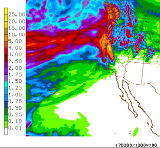
Thursday will be the last dry day for Washington, with a line up of increasingly wet storms invading the State starting Friday. The forecast for the 72h precipitation ending 4 PM Sunday (see below) says it all: WET, with some of the mountain areas getting 2-5 inches, with more over northern CA.
 The big concern right now is about freezing rain and snow in the Columbia Gorge and Portland. In many ways, the situation is FAR less threatening than in early/mid January and less ominous than feared earlier this week. The temperatures are much warmer around Portland this time and it is clear that substantially warmer air will invade on Friday, making an extended wintry period unlikely in the Rose City. Eastern WA will have snow for sure.
The situation at 10 PM Wednesday is shown by a sea level pressure forecast, with low-level air temperature shown as well. Blue is cold air. Frigid air is now over eastern Washington, with just moderately below normal temperatures over western WA. A large pressure difference across the Cascades is producing strong winds in the Columbia Gorge and parts of Portland.


 The next pulse of precipitation will come in Friday morning (see forecast at 4 AM) and by that time the temperatures will be above freezing aloft. Thus, the threat of snow will be over. There will be a chance of freezing rain over the western side of Gorge into Friday afternoon, after which it will warm sufficiently to be rain even there.


____________________
The last week has been relatively dry and cool, but the circulation pattern over the West Coast is about to change as high pressure aloft is replaced by moderate, moist southwesterly flow.
Thursday will be the last dry day for Washington, with a line up of increasingly wet storms invading the State starting Friday. The forecast for the 72h precipitation ending 4 PM Sunday (see below) says it all: WET, with some of the mountain areas getting 2-5 inches, with more over northern CA.

The situation at 10 PM Wednesday is shown by a sea level pressure forecast, with low-level air temperature shown as well. Blue is cold air. Frigid air is now over eastern Washington, with just moderately below normal temperatures over western WA. A large pressure difference across the Cascades is producing strong winds in the Columbia Gorge and parts of Portland.

The observations at 8 PM (temp is black, gusts in red), show mid-30s in Portland and teens in eastern WA. Cold enough to snow.
Tomorrow, a very weak warm front will move northward over Oregon (see forecast precipitation for the 3-h ending 4 PM Thursday). There could be some very light snow to start, and as warm air surges in aloft, some light freezing drizzle.


After than, one wet/warm system after another will hit our region. The precipitation totals forecast by the NWS GFS system for the next 180 h (7.5 days) is amazing (see below), with the West Coast for central CA northward flooded by heavy precipitation. Temperatures will be cool enough for massive snows in the mountains.
To illustrate, here is the prediction 72h snowfall ending 4 AM Sunday. Nearly three feet at higher elevations in the Cascades and more snow over eastern WA. Lots in the Rockies as well.

As I have said in an earlier blog, the West Coast drought is effectively over.
Post a Comment