Historically, the snowpack over the Pacific Northwest mountains peaks right about now--the last days of March to first week in April--something that is illustrated by the figure below (a figure from Amar Andalkar's wonderful skiing the Cascade volcanoes site).


And there is another issue, snow is highly reflective, so a lot of the sun over the mountains is reflected to space rather warm the surface. This is an issue regarding our regional impacts of global warming. As the earth warms, our mountain snowpack will lessen, which will allow more solar radiation to be absorbed, which causes more warming and thus melted snow. A positive feedback for destroying snow and warming our region.


This year the regional mountain snowpack surged in early March, but has stagnated the last week or so because of warmer weather, something illustrated by the snowpack numbers at the Olallie Meadows SNOTEL site near Snoqualmie Pass (dark blue is this year's snow water equvalent, SW), light blue is normal.

Why does our snowpack hit its maximum around April 1, a time when the sun is getting quite strong (equivalent to mid-September)?
Before we talk about that, here are the latest snowpack numbers (percent of normal) around the West. Virtually all the West is well above normal for SWE (total amount of water in the snowpack), with California's Sierra Nevada being crazy high.
As noted by Mark Albright, past state climatologist, with 720 inches of snowfall through 23 March, Mt Baker Ski Area has recorded its snowiest winter since the big snow years of 2011-12 with 808 inches and 2010-11 with 857 inches. This is going to be a long ski season for the Northwest. Enough snow that Washington DOT is delaying its clearing of North Cascades Highway (SR20); according to WA DOT it may be the latest opening since 1974. This WSDOT photo of SR 20 near Liberty Bell mountain shows some of the challenges, including several avalanche chutes.

So why does Cascade snowpack peak around April 1? It is all about temperature. Since our weather systems come off the Pacific, it is good to look at the vertical sounding at Qullayute, on the NW WA coast. Below are the climatologies of temperature there for three levels (925 hPa--around 2500 ft, 850 hPa--around 5000 ft, and 700 hPa--around 10,000 ft). Those levels pretty much bracket the Northwest high terrain. You will notice that they have a similar characteristic: temperatures aloft don't start warming until mid-April. I talked about that in a previous blog---the atmosphere has a lot of thermal inertia, which means it takes a while for the increasing warming at the surface to influence the deeper atmosphere. So with temperatures remain cool and precipitation still hitting our region, snow accumulation can continue into early April.
And there is another issue, snow is highly reflective, so a lot of the sun over the mountains is reflected to space rather warm the surface. This is an issue regarding our regional impacts of global warming. As the earth warms, our mountain snowpack will lessen, which will allow more solar radiation to be absorbed, which causes more warming and thus melted snow. A positive feedback for destroying snow and warming our region.
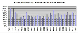
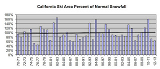
Those effects will become profound later in the century, but so far there have been only minimal losses of Cascade snowpack. Larry Schick of the US Army Corps of Engineers, also known as the Grand Poobah of NW Powder, sent me some snow statistics of major regional ski areas provided by Tony Crocker (his best snow web site has lots of good material). Both the Pacific Northwest and California ski areas show little trend (black line) through 2013.
And an analysis of snow water equivalent (SWE) of over 200 SNOTEL sites around the NW through 2016 by Mark Albright suggests little trend over the past 30 years (see below)

Now before some folks get irritated with me, let me underline that this will all change by mid-century as greenhouse gases increases. We have been "protected" by the slow to warm eastern Pacific. but eventually the radiative effects of increasing greenhouse gases will warm the lower atmosphere even here causing substantially reduce snowpack.
Finally, what about the next week? The latest ECMWF snow forecast shows some additional snow at higher elevations across our region. Enjoy.

Post a Comment