The ominous music rises...in a galaxy far, far away... a band of unnatural moisture strikes incessantly on a sodden land ...

The satellite-observed water vapor imagery tonight highlights the menace, unimaginably wide and extending across the largest ocean basin of the planet. Its tentacles spread so wide that is covers the entire west coast of the U.S. Extraordinary for April.


And a strange ship has just docked in Elliot Bay.

But this is a scientific blog, so let's consider the facts. During the past week, as much as five inches has fallen on the windward side of the coastal mountains from northern CA to the Olympics, with similar amounts over the Oregon/southern WA Cascades.

And it is not over. The forecast for the 72hr total precipitation ending Friday AM shows as much as 2-5 inches in the Cascades.

The dark side of the atmosphere has produced, well, dark skies, as illustrated by the Space Needle cam later this afternoon. No sun glasses needed.

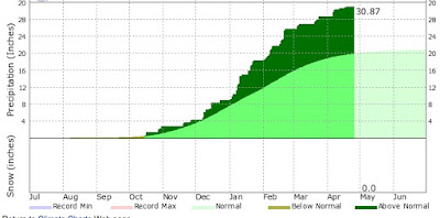
And as noted in my previous blog, we are experiencing the wettest October 1- April 30th in the history of Seattle, as depressingly shown in this figure of cumulative precipitation at Sea-Tac for the water year (starting October 1). The dark green show the amount above normal (44.69 inches total so far). At this point in time, we should have 30 inches.


The satellite-observed water vapor imagery tonight highlights the menace, unimaginably wide and extending across the largest ocean basin of the planet. Its tentacles spread so wide that is covers the entire west coast of the U.S. Extraordinary for April.
An infrared satellite imagery at the same time shows a disturbing form, something out of horror/sci-fi films.
And a strange ship has just docked in Elliot Bay.

But this is a scientific blog, so let's consider the facts. During the past week, as much as five inches has fallen on the windward side of the coastal mountains from northern CA to the Olympics, with similar amounts over the Oregon/southern WA Cascades.
And it is not over. The forecast for the 72hr total precipitation ending Friday AM shows as much as 2-5 inches in the Cascades.

The dark side of the atmosphere has produced, well, dark skies, as illustrated by the Space Needle cam later this afternoon. No sun glasses needed.
And as noted in my previous blog, we are experiencing the wettest October 1- April 30th in the history of Seattle, as depressingly shown in this figure of cumulative precipitation at Sea-Tac for the water year (starting October 1). The dark green show the amount above normal (44.69 inches total so far). At this point in time, we should have 30 inches.
Did you know that the West Coast has been so wet, that San Francisco had more than Seattle's normal precipitation this water year? Unbelievable but true.
Here is the proof, with a cumulative precipitation chart for San Fran--more than 30 inches so far.
No wonder the SF imports in our high-tech industries haven't run back to the Bay area...it has been savage even there.
Darth Vapor will hold its grip on us for a few more days...
Post a Comment