Wildfire smoke from distant fires has now moved in aloft above western Washington, pushed by southerly and southeasterly flow aloft.
The sky again has that hazy look, with the sun taking on orange and red hues.
But air quality remains good near the surface west of the Cascade crest.
The view from Crystal Mountain towards Mount Rainier says it all. Below is this morning versus July 19th. Wow. I'm glad I did my hiking last Sunday.
The NOAA HRRR model shows the forecast smoke over the region around noon. Red indicates fairly high levels.
But the smoke is staying aloft over western Washington, something shown by an east-west vertical cross section of smoke at the same time. Not so good at the surface east of the Cascade crest.
Yesterday and overnight some VERY welcome rain fell over the Cascades and northeast Washington...as much as a quarter of an inch (see 24-h totals below). EXACTLY where we needed it to lessen the wildfire threat (click to expand).
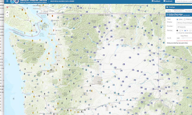
And with all the clouds and smoke hanging around, eastern Washington is RADICALLY cooler today, with some locations 25F cooler than yesterday (the maps shows the 24- temperature change between today and yesterday)
Wildfire threat is way down and this gives firefighters a chance to gain an upper hand.
Finally, the models are converging together on the cool/rainy period starting on Thursday....a period that should greatly lessen the wildfire threat for weeks.
Take a look at the 48-h total precipitation ending 5 AM Sunday. Unbelievably wet, with some areas getting over 2 inches of rain. If this verifies, the fires near Winthrop and southern BC will get radically knocked back.
All and all, a very favorable situation.


Post a Comment