On Friday night there were spectacular, jaw-dropping, lenticular clouds east of the Cascades. The same clouds that started the UFO craze back in the late 1940s.
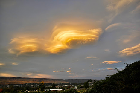
The image below taken by Mindy Stern of Cashmere, as the sun was setting Friday evening, is one of the most beautiful I have ever seen.
Lenticular clouds comprised of multiple plates in the vertical, with a few "single plate" lenticular in the background. The lighting was perfect. Stunning

Carl Buck of East Wenatchee took the following pictures at 8:30 PM from East Wenatchee. Gorgeous.


These lenticular (or lens-shaped) clouds are the result of moist air passing over a mountain barrier, something I will explain in a moment.
But first, could we see these clouds from space? Did our weather satellites show their development from aloft?
The answer is yes.... and let me show you. Below is a high-resolution visible satellite image for 8:01 PM on Friday night. There are some lower clouds over the Cascades and western Washington, but the much higher mountain/wave lenticular clouds are clearly evident. I put a few red arrows to show you the location I am talking about.

The satellite image at 8:26 PM is amazing. The sun is illuminating the western sides of the mountain wave clouds with a golden light. Just the time when some of the most dramatic images were being taken.

Extraordinary lenticular clouds such as shown above are associated with high-amplitude, vertically propagating atmospheric waves produced by relatively moist air being forced over a significant terrain barrier.
To give you a better idea of what is going on, here is a schematic of such a situation, produced by the UCAR COMET project. Waves are produced by air being forced to go over the mountain, with such waves extending vertically and amplifying. Rising air causes air to become saturated, producing clouds aloft.

On Friday evening, an approaching weather system caused the winds over the Cascades to increase, helping to produce mountain waves. And the air was moistening, contributing to the development of clouds downstream of the terrain where the air was rising.
The vertical structure of the atmosphere approaching the mountains had to be right to get such nice downstream waves. For example, there was a stable layer near crest level of the terrain, which temperature was nearly constant with height.
I am an atmospheric modeler (both weather prediction and climate prediction) and I was very gratified to see that our very high resolution (1.3 km grid spacing) forecasts were able to realistically simulate and predict these wave clouds (see below). We have come a long way!

Simulated clouds at 8 PM Friday from a 15-h forecast of the UW WRF model
Finally, in case you are interested, observed precipitation on Saturday (see below for last 48h of precipitation) verified the predictions quite well, with observed heavy rainfall on the western sides of the Cascades getting to 1-2 inches. Good wetting along the coast and over northeast WA. Less over Puget Sound, which was in the rain shadow of the Olympics. Very helpful in reducing wildfire danger for a few days, particularly since there was no lightning.

Post a Comment