We are now enjoying a short period of relatively dry conditions before the next surge of moisture reaches our shores, starting later on Sunday.
With the expected precipitation, September precipitation over the region will come in way above normal.
And the recent cool, wet weather has had one positive impact: local wildfires are rapidly declining, with MUCH less smoke apparent in satellite pictures.
Compare the NASA MODIS visible satellite imagery for Tuesday (Sept. 21) with earlier this month (Sept. 7)--see below. A LOT more smoke two weeks ago! And with the upcoming rain, the remaining Northwest fires will become history.
River levels and streamflow are generally near normal around the region, which is good for supporting local salmon runs around the region.
The Soggy Story for Next Week
The dry conditions today through Saturday are associated with a ridge of high pressure aloft over the eastern Pacific (see below). You can see the large high pressure/height center positioned west of California in the map for this morning at 5 AM.
The latest forecast shows rain reaching northwest Washington on Sunday afternoon (the 24-h amounts ending 5 PM Sunday are shown below). So from Tacoma south and east, Sunday afternoon will generally be dry.
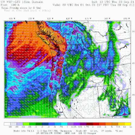
After Sunday, we will be buffeted by storm after storm. Below is the total precipitation accumulation forecast through 5 PM Friday. Wow.
Southwestern BC and northwest Washington will be hit very hard, with as much as 5-10 inches in the mountains.
The latest 6-10 day precipitation forecast of the NOAA Climate Prediction Center is consistent with this modeling. Saturday will be a great day for outdoor activity. Early Sunday will be ok...and then the faucet turns on.
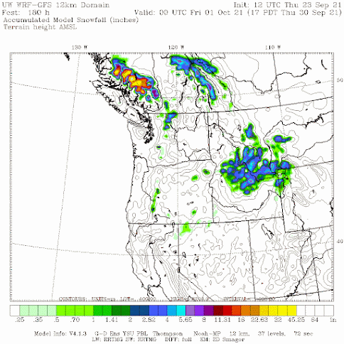
And these wet systems will be cool enough to start the snow season at higher elevations, particularly in British Columbia.
__________________________________________________Atmospheric Sciences 101
Like last year, I am teaching atmospheric sciences 101: a general introduction to weather and climate, this fall. You can learn more about the class on the class website. I talk about everything from the basics of the atmosphere, to weather prediction, thunderstorms, hurricanes, and local weather to global warming and climate.
I will be teaching the class in person at the UW, but will also make it available over zoom. Thus, folks can take it remotely.
If you are over 60, you can take the class through the ACCESS program for a very nominal charge (something like $15). Last year I had over 125 folks do so.
So if you are a UW student looking to learn about weather or a non-student interested in the topic, I welcome you to join me this fall. My first class is on September 29th.


Post a Comment