Some light snow has fallen around Bellingham and environs in the Fraser River outflow (see below), and modest snow has also fallen to the southeast of the Olympics over portions of the Kitsap Peninsula. Snow has whitened the region above roughly 1000ft, and heavy snow continues to fall in the mountains.
I5 north of Bellingham
But the real action is ahead, both in cold and snow, and it appears that we have a shot of more extensive lowland snow on Thursday.
The Cold
A modified Arctic front will move through Puget Sound around midnight. Temperatures will plummet with its passage, which will also be accompanied by a dramatic shift in wind direction to the north. Cold air has already started to pour through the Fraser River gap into Northwest Washington, with temperatures dropping into the mid to low 30s, borne by strong northeasterly winds (see map for 11 AM, red numbers are gusts in mph).
The forecasts are now consistent and reliable.... western Washington will experience temperatures dropping to the lower to mid-teens, while eastern Washington will get the full arctic treatment, with highs in the single digits and lows below zero (see European Center temperature forecasts below)
A number of eastern Washington locations will experience more than 100F swings between the highs last June and the lows this week. A few westside locations may as well--which will be unprecedented in the historical record.
Many locations around the Northwest will experience daily (not all-time) low-temperature records. And if you want to be impressed, consider the temperature at around 800 meters above the surface at Quillayute on the Washington NW coast (925hPa pressure level). It will be the second coldest time in the 73-year record there (see plot below, the red star is the forecast temperatures at that level, the blue line shows the record low temperatures for that date).
Snow
Like politics, snow is essentially local in nature. Today, snow is all about temperature, with the atmosphere being generally a bit too warm for snow near sea level.
There is light snow over NW Washington because of the cold air coming out of the Fraser River Valley.
This evening, as strong northeasterly flow pushes out of the Fraser River Valley, it will be forced upwards on the NE side of the Olympics, producing localized heavy snow. The rainshadow folks around Sequim and Port Townsend will experience precipitation like the rest of us.....you have to smirk about that.
3-h snowfall and low-level winds valid at 7 PM tonight
Why is the cold air pouring out of the Fraser River valley and points north?
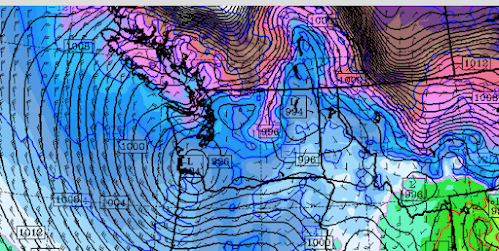
Because a low-pressure system will be moving eastward across southwest Washington (see surface map at 4 AM tomorrow morning). With intense cold, high pressure over BC, and lower pressure near the entrance to the Columbia River, cold air is being pushed to the south.
Sea level pressure (solid lines, and 800-meter temperatures, colors)--brown and purple are the coldest temperatures.
Overnight the leading edge of the cold air, the arctic front, will move though--not only supplying cold air but providing uplift that produces precipitation--snow. That will be aided by an upper-level trough moving through.
By tomorrow morning, most of western Washington will have some light snow.....generally no more than an inch or two. The 24h snowfall ending 4 PM Sunday is shown below. Greens are less than 2 inches, with blues (2-4 inches) generally east of Puget Sound.
But this is snowfall....which includes snow that will melt. The amount predicted to be on the ground at 10 AM tomorrow is not so impressive (see below). Colors start at 3.7 inches. Grays indicate lighter snow amounts (in meters).
Enough snow to whiten the region a bit. And snow is a cooling machine...reflecting solar radiation to space and emitting infrared radiation from the surface.Finally, the big lowland snow threat in the future. On Thursday, cold air will be in place and a Pacific front will approach, resulting in precipitation (snow). The 24-h snowfall ending 4 AM Friday is much more significant for central Puget Sound. More on this as we get closer.


Post a Comment