Ahead of us we have a major windstorm, a minor windstorm, and heavy precipitation. And this morning we had a tornado for good measure.
A double low center is moving through today, with a weaker low last night and its stronger sibling during the next few hours. In fact, the infrared satellite image around 10 AM showed the second low center quite well--you see the swirl east of the Strait of Juan de Fuca? That's it.

East and southeast of low there was cold, unstable air producing strong convection and thunderstorms.

Some of these thunderstorm were very intense and produced rotation, with at less one tornado that hit Manzanita on the northern Oregon coast (see funnel cloud and damage picture below).


The winds last night and this morning (see below for the max gusts for the 24h ending noon Friday), gusted to 30-40 mph over Seattle, but much stronger of the the coast, where 40-70 mph gusts have been noted. Some power outages have occurred, showing our vulnerability with leafed trees and untested branches.

Winds are about to pick up around Puget Sound, as the the low center shown above moves north of Puget Sound. Perhaps 30-40 mph gusts over land, 35-50 mph over and near water. A few more power outages.
But the big storm will be tomorrow, late afternoon and evening. The noon infrared satellite picture shows the feature (inside the white oval).

I have looked at the latest forecast model output and they are all on pretty much the same page, which increases forecast confidence substantially. The bottom line is that we have a dangerous storm, comparable to the 2006 Chanukah Eve storm or the 1993 Inauguration Day Storm, one that is following nearly a perfect track to produce strong winds over the Puget Sound region. And the coast is guaranteed to be hit hard.
Let me show you the UW WRF version of this event, with an important note. This is going to be a relatively small storm. If the track of storm is shifted only a small amount (50-100 miles) from the forecast track, the winds in Seattle or other locations could be changed substantially. Thus, there is some uncertainty in the forecast.
At 5 AM Saturday, the low is off southern Oregon
 By 2 PM, it has revved up and found right off the Columbia bars.
 At 8 PM Saturday the low is moving over southern Vancouver Island.
Game time. This is when the winds would be strongest.
 Now lets look at the max winds (gusts) from the UW's ultra-high resolution model domain (1.3 km grid spacing) during the primo wind time.
At 5 PM Saturday, gusts over 70 mph along the southern WA coast, south of the low center. No big winds over Seattle yet.
 By 7 PM, the low is centered near Port Angeles, with 50-60 mph gusts over the Puget Sound region and much stronger winds of NW Washington and the coast.
 By 9 PM, strong winds still over NW Washington and calming down a bit elsewhere.

If the above solution is correct, several hundred thousand people in western WA will lose power. The key safety issue is to keep away from trees during the 4-6 hr of greatest threat. Typically, there are several deaths and injuries associated with falling trees, some of which occur when trees fall on moving cars.
I will be updating during the day tomorrow. Enjoy the storm but keep safe.
_____________________________
Public Service Message: I-732, the revenue-neutral carbon tax swap, will help reduce Washington State's greenhouse gas emissions, make our tax system less regressive, and potentially serve as a potent bipartisan model for the rest of the nation. More information here. Some opponents of I-732 are spreading false information, suggesting that I-732 is not revenue neutral. This claim can be easily disproven as discussed here. I strongly support I-732 as do many UW climate scientists.
__________________________________

A double low center is moving through today, with a weaker low last night and its stronger sibling during the next few hours. In fact, the infrared satellite image around 10 AM showed the second low center quite well--you see the swirl east of the Strait of Juan de Fuca? That's it.
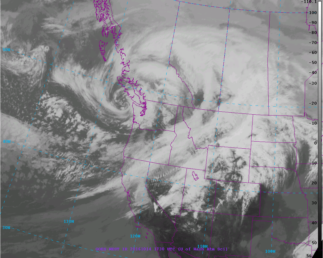
East and southeast of low there was cold, unstable air producing strong convection and thunderstorms.
Some of these thunderstorm were very intense and produced rotation, with at less one tornado that hit Manzanita on the northern Oregon coast (see funnel cloud and damage picture below).

The winds last night and this morning (see below for the max gusts for the 24h ending noon Friday), gusted to 30-40 mph over Seattle, but much stronger of the the coast, where 40-70 mph gusts have been noted. Some power outages have occurred, showing our vulnerability with leafed trees and untested branches.
Winds are about to pick up around Puget Sound, as the the low center shown above moves north of Puget Sound. Perhaps 30-40 mph gusts over land, 35-50 mph over and near water. A few more power outages.
But the big storm will be tomorrow, late afternoon and evening. The noon infrared satellite picture shows the feature (inside the white oval).
I have looked at the latest forecast model output and they are all on pretty much the same page, which increases forecast confidence substantially. The bottom line is that we have a dangerous storm, comparable to the 2006 Chanukah Eve storm or the 1993 Inauguration Day Storm, one that is following nearly a perfect track to produce strong winds over the Puget Sound region. And the coast is guaranteed to be hit hard.
Let me show you the UW WRF version of this event, with an important note. This is going to be a relatively small storm. If the track of storm is shifted only a small amount (50-100 miles) from the forecast track, the winds in Seattle or other locations could be changed substantially. Thus, there is some uncertainty in the forecast.
At 5 AM Saturday, the low is off southern Oregon


Game time. This is when the winds would be strongest.

At 5 PM Saturday, gusts over 70 mph along the southern WA coast, south of the low center. No big winds over Seattle yet.


If the above solution is correct, several hundred thousand people in western WA will lose power. The key safety issue is to keep away from trees during the 4-6 hr of greatest threat. Typically, there are several deaths and injuries associated with falling trees, some of which occur when trees fall on moving cars.
I will be updating during the day tomorrow. Enjoy the storm but keep safe.
_____________________________
Public Service Message: I-732, the revenue-neutral carbon tax swap, will help reduce Washington State's greenhouse gas emissions, make our tax system less regressive, and potentially serve as a potent bipartisan model for the rest of the nation. More information here. Some opponents of I-732 are spreading false information, suggesting that I-732 is not revenue neutral. This claim can be easily disproven as discussed here. I strongly support I-732 as do many UW climate scientists.
__________________________________
_____________________________
New Weather Smartphone App, uWx
At the UW, we have developed a wonderful FREE weather app for Android smartphones that also collects pressure for use in weather forecasting. If you want to try it, please go to the Google PlayStore and download it.
At the UW, we have developed a wonderful FREE weather app for Android smartphones that also collects pressure for use in weather forecasting. If you want to try it, please go to the Google PlayStore and download it.
Post a Comment