There are significant changes in the forecast.
Currently, we have an atmospheric river (a relatively narrow current of moisture and precipitation) aimed right for our regio). This is evident in a recent infrared satellite image (see below)


Over the past 24 hrs (ending 9 AM), some locationz on the windward slopes of the Olympics have received 2-4 inches, with substantial amounts on the windward slopes of other terrain (like the N. Cascades.) (the figure below only shows locations with more than 1 inch)

Plenty of rain today, with greatest amounts over Oregon (see 24h precip ending 5 AM Friday).

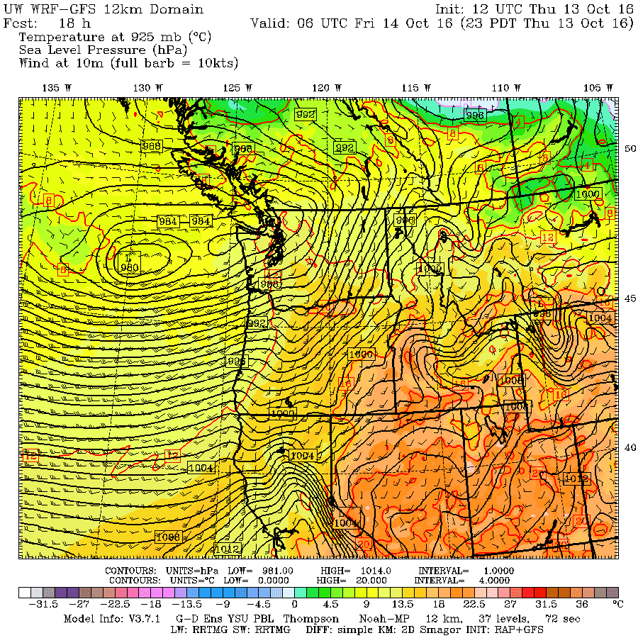
Most of you are probably more interested in windstorms...so lets consider that now. Right now it appears that the late Thursday/Friday morning event will not be a severe one. One problem for that storm is that we are really working with an initially amorphous, almost double system, rather than a consolidated single strong system. Here is the surface pressure forecast for 11 PM...you can see the stretch out low, with lows of pressure gradient (and strong winds to the south).
 By Friday afternoon, a more consolidated low passes to our north and a large pressure gradient develops over western WA.
 As a result, it will get windy during Friday afternoon, with sustained winds reaching 15-25 mph with gusts of 30-40 mph over Puget Sound, stronger over the coast and NW WA. Some power outages, but nothing catastrophic.

But now, lets talk about what you REALLY want to know about. The Saturday storm, which potentially can be much stronger, representing the remnants of Typhoon Songda. The confidence in earlier forecasts were lessened by the different solutions of the US model (GFS) and the vaunted European (ECMWF) model--a classic situation for forecasts. The GFS was going for a historic storm with a central pressure in the 950s mb that hit Vancouver Island, while the ECMWF solution was weaker (960s) and farther south (passing over Seattle!).
Well, the new US runs have now shifted to a compromise solution, halfway to the ECMWF track and weaker, but still a remarkably intense storm for our region. And the storm is a bit later. Let me show you.
The surface forecast (sea level pressure) for 5 AM Saturday show a strong low (980 hPa) off southern Oregon.
 By 5 PM Saturday, it has revved up to 968 hPa. A very intense tight storm. Such rapid intensification is know as "bombogenesis." Not kidding
 By 11 PM on Saturday, the storm is just north of the border and a huge gradient is over western WA. Big winds.
 Two things. This track is the perfect track of strong winds over Puget Sound. Second, the worst windstorms are rapidly intensifying as the make landfall...like this storm.
The wind forecast map (for sustained winds) at 11 PM Saturday suggest sustained winds of 25-35 mph, with gusts of 35-65 mph over Puget Sound.
 The 12 UTC European Center run is in and the forecast is very close to the US GFS. Here is the 5 PM Saturday prediction... 967 hPa off of SW WA.
 The gust forecast from the European Center for the 6-h ending 11 PM Saturday shows 50-70 knot gusts over western WA. That is serious.

Bottom line: the Saturday storm is the big windstorm threat and has the potential to be one of the strongest windstorms we have seen in a few years. There is still uncertainty in the forecast but it is far less than earlier.
Keep in mind what we are trying to do...forecast the exact track and intensity of a storm that is now thousands of miles away and currently very weak. If our track if off by 100 miles, the forecast is radically changed at nearly all locations. It is amazing we can even attempt to do this. So we still have to watch this system very carefully and update the forecast as we get close.
____________
I strongly support I-732, the revenue-neutral carbon tax swap, which help reduce Washington State's greenhouse gas emissions, make our tax system less regressive, and potentially serve as a potent bipartisan model for the rest of the nation. More information here.

Currently, we have an atmospheric river (a relatively narrow current of moisture and precipitation) aimed right for our regio). This is evident in a recent infrared satellite image (see below)
Or in the forecast for the total moisture in the vertical valid at 11 AM. Blue is large amounts

Over the past 24 hrs (ending 9 AM), some locationz on the windward slopes of the Olympics have received 2-4 inches, with substantial amounts on the windward slopes of other terrain (like the N. Cascades.) (the figure below only shows locations with more than 1 inch)
Plenty of rain today, with greatest amounts over Oregon (see 24h precip ending 5 AM Friday).

Most of you are probably more interested in windstorms...so lets consider that now. Right now it appears that the late Thursday/Friday morning event will not be a severe one. One problem for that storm is that we are really working with an initially amorphous, almost double system, rather than a consolidated single strong system. Here is the surface pressure forecast for 11 PM...you can see the stretch out low, with lows of pressure gradient (and strong winds to the south).


But now, lets talk about what you REALLY want to know about. The Saturday storm, which potentially can be much stronger, representing the remnants of Typhoon Songda. The confidence in earlier forecasts were lessened by the different solutions of the US model (GFS) and the vaunted European (ECMWF) model--a classic situation for forecasts. The GFS was going for a historic storm with a central pressure in the 950s mb that hit Vancouver Island, while the ECMWF solution was weaker (960s) and farther south (passing over Seattle!).
Well, the new US runs have now shifted to a compromise solution, halfway to the ECMWF track and weaker, but still a remarkably intense storm for our region. And the storm is a bit later. Let me show you.
The surface forecast (sea level pressure) for 5 AM Saturday show a strong low (980 hPa) off southern Oregon.


The wind forecast map (for sustained winds) at 11 PM Saturday suggest sustained winds of 25-35 mph, with gusts of 35-65 mph over Puget Sound.


Bottom line: the Saturday storm is the big windstorm threat and has the potential to be one of the strongest windstorms we have seen in a few years. There is still uncertainty in the forecast but it is far less than earlier.
Keep in mind what we are trying to do...forecast the exact track and intensity of a storm that is now thousands of miles away and currently very weak. If our track if off by 100 miles, the forecast is radically changed at nearly all locations. It is amazing we can even attempt to do this. So we still have to watch this system very carefully and update the forecast as we get close.
____________
I strongly support I-732, the revenue-neutral carbon tax swap, which help reduce Washington State's greenhouse gas emissions, make our tax system less regressive, and potentially serve as a potent bipartisan model for the rest of the nation. More information here.
Post a Comment