Forecasting snow over western Washington is made hugely more difficult because our temperatures are often marginal for snow, with a few degrees making all the difference.
And the snow forecast for Monday is no different.
Whenever air is coming off the relatively mild (roughly 50F) Pacific, it is difficult to get lowland snow unless the air is very, very cold aloft.
As scheduled, a strong cold front moved through this morning with cool onshore flow in its wake. This transition was clearly shown in the winds and temperatures over Sea-Tac Airport (see time-height cross section below, red temperatures, blue are winds, time goes from right to left in GMT/Z/UTC, and heights are in pressure --850 is roughly 5000 ft). The wind shifted around 0412 (Dec 4 and 12 UTC-4 AM) and the temperatures dropped.
 It cooled enough aloft that a few areas above 500 ft or in intense showers (which brings the snow level down momentarily) that snow reached the surface at some Puget Sound locations. Here is an example from Snoqualmie Ridge

Or Ken's Korner on Whidbey Island:

The current snow threat is associated with cold unstable air that is being lifted by an upper level trough (or disturbance). The latest infrared satellite image Sunday night show the convective showers associated with the unstable air (the white mottled look). An area of enhanced showers is off our coast and headed our way overnight--that is the immediate threat.

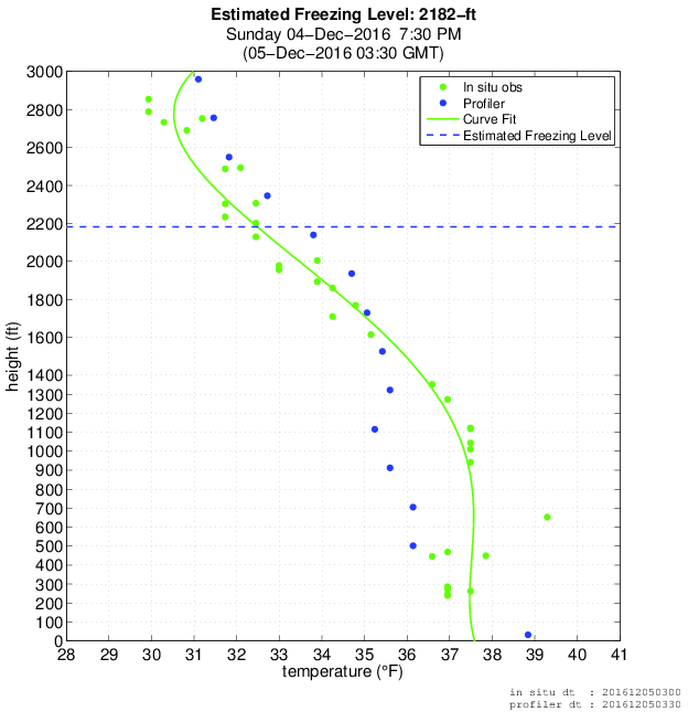
But although the air has cooled considerably, it is still marginal for snow near sea level and near the water. In fact, the freezing level rose a bit during the day and is now (7:30 PM) roughly 2200 ft. Keep in mind that the snow level (the level below which the precipitation is all rain) is about 1000 ft below the freezing level (the altitude of 0C). Thus, the snow level is now around 1200 ft.
 The approaching precipitation will bring the freezing and snow levels down (due to evaporation and melting of precipitation), but it will be difficult to bring snow all the way down to sea level, particularly locations near relatively warm Puget Sound. Let's look at the latest model runs.
The NOAA/NWS HRRR (High Resolution Rapid Refresh) snow total through noon shows only .1-1 inch over most of Seattle, but much higher amounts south of Olympia and the Olympics.

The even higher resolution UW model run for the 24-h snow ending 4 PM Monday is similar, but with more snow over Snohomish County and north Seattle (few inches).

The marginal (and thus uncertain) nature of this event is highlighted by the latest National Weather Service SREF ensembles for snow at Sea Tac (452 ft). The mean total snow is around 3/4 of an inch, but there is a lot of variability.

The bottom line is that if you are near Puget Sound and close to sea level, you will see mainly rain showers, perhaps accompanied by less than an inch of wet snow. But away from the water and a few hundred feet up, an inch or two is possible. The roads should be ok other than steep hills since the soil is warm. Higher up (400-800 ft), several inches are quite possible. The main area of showers/snow should get to us roughly 5-7AM--so if you are starting your commute on a hill or inland, leave extra time.
The Seattle media has already started its favorite past-time, with "live storm coverage" and it is starting to have an impact on local supermarkets (see below).

And if you think the snow will be over tomorrow...think again. Much colder arctic air will surge southward Tuesday morning, with potential snow in Sequim/Port Angeles and even northern Puget Sound.

And the snow forecast for Monday is no different.
Whenever air is coming off the relatively mild (roughly 50F) Pacific, it is difficult to get lowland snow unless the air is very, very cold aloft.
As scheduled, a strong cold front moved through this morning with cool onshore flow in its wake. This transition was clearly shown in the winds and temperatures over Sea-Tac Airport (see time-height cross section below, red temperatures, blue are winds, time goes from right to left in GMT/Z/UTC, and heights are in pressure --850 is roughly 5000 ft). The wind shifted around 0412 (Dec 4 and 12 UTC-4 AM) and the temperatures dropped.

Picture taken by Rob Nelson
Or Ken's Korner on Whidbey Island:

Picture courtesy of Susan Kieffer
The current snow threat is associated with cold unstable air that is being lifted by an upper level trough (or disturbance). The latest infrared satellite image Sunday night show the convective showers associated with the unstable air (the white mottled look). An area of enhanced showers is off our coast and headed our way overnight--that is the immediate threat.
But although the air has cooled considerably, it is still marginal for snow near sea level and near the water. In fact, the freezing level rose a bit during the day and is now (7:30 PM) roughly 2200 ft. Keep in mind that the snow level (the level below which the precipitation is all rain) is about 1000 ft below the freezing level (the altitude of 0C). Thus, the snow level is now around 1200 ft.
The NOAA/NWS HRRR (High Resolution Rapid Refresh) snow total through noon shows only .1-1 inch over most of Seattle, but much higher amounts south of Olympia and the Olympics.

The even higher resolution UW model run for the 24-h snow ending 4 PM Monday is similar, but with more snow over Snohomish County and north Seattle (few inches).

The marginal (and thus uncertain) nature of this event is highlighted by the latest National Weather Service SREF ensembles for snow at Sea Tac (452 ft). The mean total snow is around 3/4 of an inch, but there is a lot of variability.
The bottom line is that if you are near Puget Sound and close to sea level, you will see mainly rain showers, perhaps accompanied by less than an inch of wet snow. But away from the water and a few hundred feet up, an inch or two is possible. The roads should be ok other than steep hills since the soil is warm. Higher up (400-800 ft), several inches are quite possible. The main area of showers/snow should get to us roughly 5-7AM--so if you are starting your commute on a hill or inland, leave extra time.
The Seattle media has already started its favorite past-time, with "live storm coverage" and it is starting to have an impact on local supermarkets (see below).
And if you think the snow will be over tomorrow...think again. Much colder arctic air will surge southward Tuesday morning, with potential snow in Sequim/Port Angeles and even northern Puget Sound.
____________
New Weather Smartphone App, uWx
At the UW, we have developed a wonderful FREE weather app for Android smartphones that also collects pressure for use in weather forecasting. If you want to try it, please go to the Google PlayStore and download it.
At the UW, we have developed a wonderful FREE weather app for Android smartphones that also collects pressure for use in weather forecasting. If you want to try it, please go to the Google PlayStore and download it.
Post a Comment