I will have an update at 9 PM Sunday.... snow has already hit some higher-elevation locations and expect more tonight...
___________________
Let me update you on the snow situation, using all the technology at my disposal, both using ensembles for a probabilistic viewpoint and high-resolution forecasts.
Let's begin by noting an important point: after the warmest November in Seattle history and mild temperatures the last few days, the road surfaces are quite warm, which will help melt any light snow falling on them. To illustrate, here is the latest air and road temperatures (road surface temperatures in rectangles) from the Seattle SnowWatch website. Most roads are in the mid to upper 40s. This will be a powerful weapon against icing during any initial onslaught of snow.


But the next 24 h, ending 4AM Tuesday is another story. The Puget Sound area gets a half to a few inches, with north Seattle to Everett getting more than the south Sound. Less near the water.

___________________
Let me update you on the snow situation, using all the technology at my disposal, both using ensembles for a probabilistic viewpoint and high-resolution forecasts.
Let's begin by noting an important point: after the warmest November in Seattle history and mild temperatures the last few days, the road surfaces are quite warm, which will help melt any light snow falling on them. To illustrate, here is the latest air and road temperatures (road surface temperatures in rectangles) from the Seattle SnowWatch website. Most roads are in the mid to upper 40s. This will be a powerful weapon against icing during any initial onslaught of snow.
As in any good forecast we should start from a probabilistic viewpoint with a clear understanding of forecast uncertainties, and as I have discussed many times in the past, ensemble forecasts (using many forecasts, each a little different) is a powerful tool to do so.
The National Weather Service 21-member GFS ensemble's cumulative snow forecast for Seattle (below) has all members (forecasts) going for some snow this week (remember this is amount of snow falling out of the sky, not depth on the ground). Black is the average of the all the forecasts and blue is the operational high-resolution GUS run. As noted earlier, there are two possible events. The first, on Monday, produces about 1-2 inches and the late Wednesday/early Thursday event has a little more (but more uncertain).
The more skillful European Center ensemble system, with more ensemble members, higher resolution, and better physics is also showing snow in two steps (see below). About a quarter of its members suggest no snow, while the rest produce generally light amount (.5-1.5 inches). The second event is much larger with 3-6 inches for several members.

The National Weather Service also has a short-range ensemble system using two models (NMM and WRF) and higher resolution (about 16 km). This system shows a mixture of solutions for the first potential snowstorm, with a lot of uncertainty and about a quarter of runs showing very little snow.
So what is my take away from all this? There is uncertainty, with about 25% of the forecasts showing virtually no snow. Roughly 75% of the model runs are predicting an inch or two at Seattle-Tacoma Airport (452 ft). The temperatures on Monday are colder than we have had, but they are still on the margin near sea level and the water. So expect a substantial gradient with elevation (more on the hills).
To get a better spatial view of the snowfall, lets look at the UW WRF, which is driven by the NWS GFS operational model. Since the GFS solution is close to the mean of the ensemble and seems to have a representative solution, the UW ultra-high resolution view should be useful.
Here are the 24h snow totals from the UW 1.3 km domain (very high resolution in the weather business). First the 24h ending 4 AM Monday. Scattered snow showers, with heaviest lowland values south and southeast of the Olympics, which is not unusual with relatively warm snow events and southerly/southeasterly flow. Not much in Seattle--thus the Seahawks game should be fine. Some snow over SW Washington.

But the next 24 h, ending 4AM Tuesday is another story. The Puget Sound area gets a half to a few inches, with north Seattle to Everett getting more than the south Sound. Less near the water.

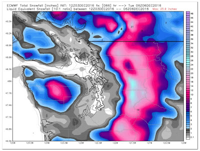
The 9-km European Center snow total through Monday evening shows loads of snow over the mountains (12-15 inches) and zero to a few inches over the lowlands (with much less near the water).
The bottom line of all this? Nothing is certain. But it appears probable (say at the 75% level) that much of the lowlands away from the water will see some light snow on Monday, particularly above a few hundred feet and over north Seattle and southwest of the Olympics.
We will leave the Wednesday event for another blog.
Post a Comment