Will update about snow at 2 PM Saturday
_______________________
As we approach the weekend, it is becoming increasingly clear that a major cold/snow event will occur next week, but with substantial uncertainty about lowland snow. One thing is certain: it will be an extraordinary week for snow in the mountains, and everyone who enjoys mountain snow recreation should get ready for a wonderful period of light, bountiful snow.
Right now the snowpack is still a bit below normal over about half of the region, with near normal snowpack (green colors below) and crazy above-normal snowpack in a few areas (the Olympics are over 250% of normal!) By the end of next week the entire mountain region should be above normal.

Early next week will be the coldest period since last January, with temperatures dropping into the 20s over western Washington..... so drain you hoses and protect vulnerable plants.
The models, both high-resolution and ensembles, are in agreement that we will have a much colder period early next week. The NWS GEFS ensemble system (21 members in gray, ensemble average black, GFS high-resolution member-blue), show unanimity of solution towards colder temperatures in Seattle early next week (highs in mid-30s, lows in the mid-20s), with modest warming at the end of the week (see plot below)
 The European Center ensemble has the same idea.

During the next week, the cold and snow will occur in roughly three acts. The first act, as shown by the low-level temperatures (colors), winds, and sea level pressure at 4 AM Sunday, will encompass a strong cold front that will move southward across our region in Sunday, bringing much colder air (see below). By later on Sunday, the air above our region will be cold enough for snow to reach near sea level.

In the second act, which will take place on Monday, cold air will extend over Washington and Oregon with frigid conditions to the east of the crest of the Rockies. A low center will form over western Washington (map at 4 PM Monday shown below). How the low develops and positions itself will determine how much snow falls in the lowlands.


 But the 24h snowfall ending 4 AM Thursday really is impressive...a foot over the mountains and several inches over the lowlands.

_______________________
As we approach the weekend, it is becoming increasingly clear that a major cold/snow event will occur next week, but with substantial uncertainty about lowland snow. One thing is certain: it will be an extraordinary week for snow in the mountains, and everyone who enjoys mountain snow recreation should get ready for a wonderful period of light, bountiful snow.
Right now the snowpack is still a bit below normal over about half of the region, with near normal snowpack (green colors below) and crazy above-normal snowpack in a few areas (the Olympics are over 250% of normal!) By the end of next week the entire mountain region should be above normal.
Early next week will be the coldest period since last January, with temperatures dropping into the 20s over western Washington..... so drain you hoses and protect vulnerable plants.
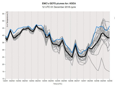
The models, both high-resolution and ensembles, are in agreement that we will have a much colder period early next week. The NWS GEFS ensemble system (21 members in gray, ensemble average black, GFS high-resolution member-blue), show unanimity of solution towards colder temperatures in Seattle early next week (highs in mid-30s, lows in the mid-20s), with modest warming at the end of the week (see plot below)

During the next week, the cold and snow will occur in roughly three acts. The first act, as shown by the low-level temperatures (colors), winds, and sea level pressure at 4 AM Sunday, will encompass a strong cold front that will move southward across our region in Sunday, bringing much colder air (see below). By later on Sunday, the air above our region will be cold enough for snow to reach near sea level.

In the second act, which will take place on Monday, cold air will extend over Washington and Oregon with frigid conditions to the east of the crest of the Rockies. A low center will form over western Washington (map at 4 PM Monday shown below). How the low develops and positions itself will determine how much snow falls in the lowlands.

In the third, and perhaps the most dramatic act, a weak occluded system approaches the coast bringing warming temperatures aloft and precipitation. With cold air in place over western Washington, the precipitation will start as snow at low levels, and perhaps a lot of snow.

Now lets look at the ensemble snow forecasts. The NOAA/NWS GEFS ensemble show a lot of variability (and thus uncertainty) with the forecast, with the average of all the forecasts (black line) and the high-resolution forecast (blue line) looking very similar. There are a few inches on Monday, a gap, and then a lot more snow later Wednesday and Thursday. All the models show at least 3 inches by the end of the period.
The European Center ensemble shows a similar picture: light snow Sunday/Monday, but heavier amounts Wednesday/Thursday.

Now, to see the spatial distribution better, lets turn to ONE forecast, the UW high-resolution prediction based on the NOAA/NWS global model. For the 24-h period ending 4 PM Monday (below), there is plenty of snow over the region, some of which extends to ground level over Puget Sound an SW Washington.


So at this point, much colder temperatures is virtually guaranteed Monday through Wednesday, and there is consensus among the ensembles that we will get at least some light snow at low levels. The warm road temperatures will help to mitigate the impacts on highways in contact with the soil.
Post a Comment