UPDATE at 10 PM Thursday
Confidence is now very high that an unusually strong coastal storm will move northward over the Pacific Northwest coastal waters on Friday morning before it makes landfall on northern Vancouver Island.
The Oregon coast will get hit particularly hard, with gusts reaching 50-70 mph. The latest European Center model forecast for 11 AM (below), shows a large low center due east of Astoria with a central pressure of 973 hPa (or mb). This is extraordinary low pressure for April and a rare event. Gusts are shown in color and reach 60-70 knots along the Oregon/southern WA coast. This means power outages along the coast.

How unusual is this event? Well, meteorologists have statistical tools to help us with this question. One way is to use standardized anomalies, in which we look at the collections of all pressures for a long period (at least several decades) at a point and determine the pressure anomaly (how different the forecast pressure is from normal). Then we divide the anomaly by the standard deviation of pressure at that point. The standard deviation (abbreviated by the Greek letter sigma) is a measure of the variability of the pressure over the period of record. This process is repeated at many points to create a map of such standardized anomalies.
The larger the standardized anomaly, the more unusual the anomaly from normal.
Here is the standardized anomaly for the pressure forecast for 5 AM Friday. For the storm center, the standardized anomaly peaks at about 5.9 (or 5.9 sigma)....this is very large, signifying that such low pressure at the point would be expected only once in seveal million hours (assuming hourly data was used and the distribution was near normal). Bottom line: this is a unique, first time event.
 Now that I have convinced you that this is an unusual event, let's look at some forecasts. The sustained (several minute average) wind for 8 AM Friday, show winds reaching 50 kt on the central Oregon coasts (again gusts are higher).

 As the storm moves up the coast, the winds will spread to the Washington coast. At 2 PM (below), sustained winds will reach 40 kts on the southern WA coast, and Seattle will be blustery with sustained 25-30 knot winds. Gusts could higher(40-50 mph, particularly near the water).

Fortunately, with a cold winter, the leafing out of the trees has been delayed, which will lessen the damage. And end of winter storms generally do less damage (because a lot of wind pruning has already occurred).
Finally, how confident am I in this forecast? Let's turn to an ensemble (many forecasts) system...the NWS SREF. The SREF ensemble prediction for wind at Astoria, OR suggests that most of the ensemble members have a similar solution of fairly strong wind.

Other ensemble systems suggest the same thing, with nearly all forecasts having a major storm off our coast. Much more confidence than the ill-fated and much smaller October 15, 2016 storm.
I suspect there still will be some limited power outages around Puget Sound, particularly since the ground is so saturated.
________________________
Help Determine Local Impacts of Climate Change
Society needs to know the regional impacts of climate change and a group at the UW is trying to provide this information with state-of-the-art high resolution climate modeling. With Federal funding collapsing, we are experimenting with a community funding approach. If you want more information or are interested in helping, please go here. The full link is: https://uw.useed.net/projects/822/home
_______________
Confidence is now very high that an unusually strong coastal storm will move northward over the Pacific Northwest coastal waters on Friday morning before it makes landfall on northern Vancouver Island.
The Oregon coast will get hit particularly hard, with gusts reaching 50-70 mph. The latest European Center model forecast for 11 AM (below), shows a large low center due east of Astoria with a central pressure of 973 hPa (or mb). This is extraordinary low pressure for April and a rare event. Gusts are shown in color and reach 60-70 knots along the Oregon/southern WA coast. This means power outages along the coast.

How unusual is this event? Well, meteorologists have statistical tools to help us with this question. One way is to use standardized anomalies, in which we look at the collections of all pressures for a long period (at least several decades) at a point and determine the pressure anomaly (how different the forecast pressure is from normal). Then we divide the anomaly by the standard deviation of pressure at that point. The standard deviation (abbreviated by the Greek letter sigma) is a measure of the variability of the pressure over the period of record. This process is repeated at many points to create a map of such standardized anomalies.
The larger the standardized anomaly, the more unusual the anomaly from normal.
Here is the standardized anomaly for the pressure forecast for 5 AM Friday. For the storm center, the standardized anomaly peaks at about 5.9 (or 5.9 sigma)....this is very large, signifying that such low pressure at the point would be expected only once in seveal million hours (assuming hourly data was used and the distribution was near normal). Bottom line: this is a unique, first time event.


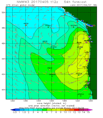
This storm will not only produce strong winds, but substantial wave action. Here are the wave height forecasts from the NOAA/NWS WaveWatch III model... the yellow indicates 8-9 meter (26-30 ft) waves. The storm/wave watching on the coast will be impressive (but stay safe if you are there)

Fortunately, with a cold winter, the leafing out of the trees has been delayed, which will lessen the damage. And end of winter storms generally do less damage (because a lot of wind pruning has already occurred).
Finally, how confident am I in this forecast? Let's turn to an ensemble (many forecasts) system...the NWS SREF. The SREF ensemble prediction for wind at Astoria, OR suggests that most of the ensemble members have a similar solution of fairly strong wind.
I suspect there still will be some limited power outages around Puget Sound, particularly since the ground is so saturated.
________________________
Help Determine Local Impacts of Climate Change
Society needs to know the regional impacts of climate change and a group at the UW is trying to provide this information with state-of-the-art high resolution climate modeling. With Federal funding collapsing, we are experimenting with a community funding approach. If you want more information or are interested in helping, please go here. The full link is: https://uw.useed.net/projects/822/home
_______________
Post a Comment