Announcement for local weather enthusiasts!
On Saturday May 6th, Larry Schick, lead meteorologist for the US Army Corps of Engineers in Seattle, will talk about Flood Risk Management and Atmospheric Rivers in Western Washington at 3pm at the Seattle Public Library Montlake branch, 2401 24th Ave. E., Seattle, WA 98112, http://www.spl.org/locations/m
______________________
When I walked outside this morning I was startled. It felt and smelled like Hawaii. Everything about the air was Hawaiian...the humidity, the smell, the character. But was it my imagination? A deception fostered by our savage winter and spring?
No, it was real. Hawaii has come to Seattle. And I can prove it.
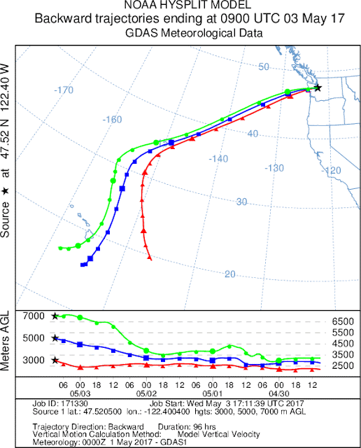
How? By calculating three-dimensional air trajectories by using the wonderful NOAA HySplit trajectory system. Specifically, I calculated back trajectories....using three-dimensional analyses produced by NOAA to figure out the origin of the air over Seattle this morning. Trajectories represent the three-dimensional path of air over time.
Here are the Hysplit trajectories ending over Seattle over the lower atmosphere (below 3000 meters...10,000 ft). They all came from near Hawaii!
The moisture in the air this morning was amazing. The dew points (a good measure of water vapor content) were very high for Seattle (upper 50sF to low 60s)--see below.
And the tropical moisture content caused the air to become saturated, with low ceilings and fog. To illustrate here is the image from the Space Needle cam around 7:15 AM this morning.
A measure of the amount of moisture in the air is something called precipitable water (PWAT)....how much water would be available if all the moisture in the atmosphere was condensed out. This morning's amount was a record for the date (the black dot is today and the red line shows the all time records for each day) at Quillayute, on the Washington coast. In fact, the highest PWAT for any date from December 1 through early May. Impressive.
And the water vapor satellite imagery from late Tuesday evening shows upper level moisture streaming northward from Hawaii toward our region.
So, if you are in Seattle, take off your shoes and grab a Mai Tai.... no need to fly to Hawaii today, just breath deeply and the air of Hawaii will fill your lungs.


Post a Comment