3:35 PM Update
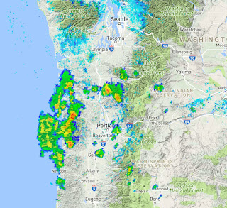
A strong line of convective showers is now approaching south Seattle. Here is the composite radar image. You don't see radar images like this around here very often....
_________________________________
The latest radar image (around 2 PM) shows precipitation associated with convection and thunderstorms, moving northward over western Oregon and SW Washington. The red areas are very heavy rain or hail.
A visible satellite image at 2 PM shows the convective clouds, with the storms over the northern Oregon coast
The National Lightning Detection Network showed many lightning strikes for the half hour ending 2 PM along the Oregon Coast.
And the Space Needle PanoCam was viewing some mid-level cumulus development that is indicative of destabilization and vertical motion.
The air over us is ripe for convection, as indicated by a critical measure (CAPE, Convective Available Potential Energy). This figure shows the values at 5 PM....very high for around here (generally we don't get to 100, and there are values of 500-1500 over western WA/OR and the Cascades)
The stability of the air lessens as the ground warms and there is clearly a northward-moving upper level disturbance that is releasing the instability.
Expect showers to reach southern Puget Sound country starting around 3PM, reaching central and northern Puget Sound 1-2 hr later.
An onshore push of marine air is beginning and the upward motion from that feature will help rev up the thunderstorms between 5 and 8 PM.
A second patch of showers and thunderstorms will occur overnight as an upper level disturbance (shortwave) moves in off the ocean, with the main action over the Cascades and eastern WA.
The simulated satellite infrared imagery at 5 PM, 8 PM and 5 AM, indicates thunderstorms over our region (the areas that are very white).
There will be plenty of showers and lightning around our region.... so boaters and golfers should be careful.
A strong line of convective showers is now approaching south Seattle. Here is the composite radar image. You don't see radar images like this around here very often....
Lots of lightning! Here are the lightning strikes for the half hour ending 3:30 PM
The latest radar image (around 2 PM) shows precipitation associated with convection and thunderstorms, moving northward over western Oregon and SW Washington. The red areas are very heavy rain or hail.
A visible satellite image at 2 PM shows the convective clouds, with the storms over the northern Oregon coast
The National Lightning Detection Network showed many lightning strikes for the half hour ending 2 PM along the Oregon Coast.
And the Space Needle PanoCam was viewing some mid-level cumulus development that is indicative of destabilization and vertical motion.
The air over us is ripe for convection, as indicated by a critical measure (CAPE, Convective Available Potential Energy). This figure shows the values at 5 PM....very high for around here (generally we don't get to 100, and there are values of 500-1500 over western WA/OR and the Cascades)
The stability of the air lessens as the ground warms and there is clearly a northward-moving upper level disturbance that is releasing the instability.
Expect showers to reach southern Puget Sound country starting around 3PM, reaching central and northern Puget Sound 1-2 hr later.
An onshore push of marine air is beginning and the upward motion from that feature will help rev up the thunderstorms between 5 and 8 PM.
A second patch of showers and thunderstorms will occur overnight as an upper level disturbance (shortwave) moves in off the ocean, with the main action over the Cascades and eastern WA.
The simulated satellite infrared imagery at 5 PM, 8 PM and 5 AM, indicates thunderstorms over our region (the areas that are very white).
There will be plenty of showers and lightning around our region.... so boaters and golfers should be careful.


Post a Comment