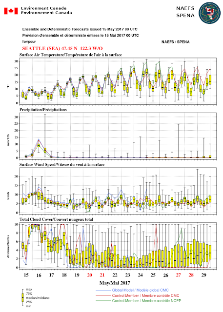
The next week will be a study of contrasts, with a wet weather system saturating the region through Wednesday, followed by a very extended period of sun, warmth, and little or no precipitation. Get out your hiking boots, bicycles, outdoor gear and sunblock...you will need them.
Tomorrow morning, an unusually strong (for May) upper low will pass through our area (see 500 hPa upper level map). As Darth Vader would say: "impressive, most impressive."
And the forecast precipitation for the 48h ending 5 AM Wednesday is also impressive (see below), with the entire northwest from northern CA to BR getting lots of water, including 1-2 inches in most of the mountainous areas. Even the Sierra Nevada is getting wet, which is really unusual.
But then the long-awaited miracle occurs and the spigot turns off and stays off. First, a modest ridge of high pressure builds aloft on Wednesday morning.
This low amplitude ridge is distorted a bit over the subsequent few days, with a several weak systems moving to the north. But the real miracle is later in the weekend when an Olympian ridge develops over the eastern Pacific, and by Monday morning (shown below) extends to Alaska. Praise to the gods.
Consist with this ridging, the latest NOAA Climate Prediction Center 6-10 day forecast indicates way below normal precipitation for Sunday to Thursday.
Or how about the vaunted European Model forecast? The 24-h totals ending 6-hr for the next two weeks shows lots of rain the next few days, but dry (or nearly dry) conditions from roughly May 18- 25.
The US/Canadian NAEFS ensemble (many forecast) system is similar to the EC prediction (check out the second panel). So my confidence is quite high in this improving trend.
A fine, dry period sometime in mid-May is not unusual, representing the interregnum between the weakening storms of the winter season and the unpleasant June-gloom of late May and June. High pressure building north cuts off the storms, but as it strengthens onshore and sinking flow increases the result is lots of ocean stratus and onshore flow by the end of May. Only when the ridge builds sufficiently with descending northerly flow does the fine weather of July begin.


Post a Comment