After one extreme heatwave and one minor one, folks are heatwave concerned, so I thought I would provide some good news.
The chances of a major warm spell, with temperatures over 90F west of the Cascades and over 100F in eastern WA, is become increasingly unlikely, based on the latest forecasts.
And then consider the time of the year. The sun is rapidly weakening now and nights are lengthening quickly. And in addition, the atmosphere has switched into what I call a La Nina pattern, with a big ridge of high pressure offshore, with cooler northerly flow over the West Coast.
But first some climatology.
Here is a plot of the climatology of extreme high temperatures for Seattle (yellow lines). Heatwave central is in late July and early August. The record highs decline in August, have occasionally risen to the mid-90s in early September, but never have gotten above 95F after mid-September and just reacj 90F by late September. The bottom drops out in October.
Our forecast models have some skill to roughly 1.5 to 2 weeks out, with small skill for big pattern changes after that.
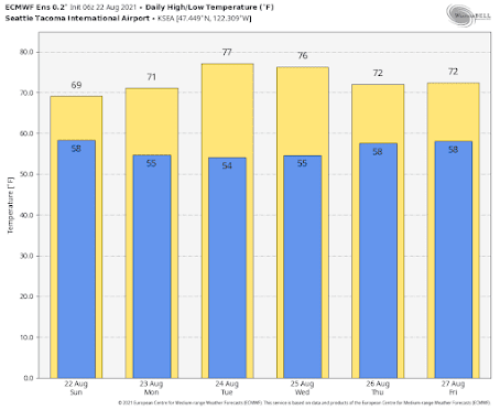
The latest European Center Ensemble Forecast, the gold standard for one-week forecasting, predicts temperatures below 80F for the rest of the month at Seattle, with today being the coldest of the bunch. Mainly 80s in eastern Washington (not shown)
Another valuable tool is the NOAA/NWS National Blend of Models (NBM), which combines a number of different forecast models statistically. Very skillful. Its forecast for Seattle through early September is similarly temperate. Just perfect really.
I could show you other forecasting systems, but they all basically suggest the same thing, with high confidence: mild temperatures with no significant heat waves ahead.
And there is NO hint of the crazy easterly winds that hit early last September, producing the terrible wildfires. We are now entering the danger season for major wildfires west of the Cascade crest (late August through Sept 15). I know about this because I am actively researching this issue. All major western WA and NW Oregon fires have resulted from strong east winds. Trust me...I will let you know if I see it set up.
Why has the weather been mild without heatwaves lately?
Because of a persistent ridge of high pressure offshore. To show this, below is a plot of the difference from normal of the height of the 500 hPa pressure surface (think of it as the difference from normal of the pressure at 18,000 ft). Yellow and orange indicate above normal...you can see the potent ridge offshore. That is the feature I am talking about.
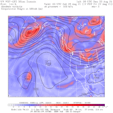
High-pressure offshore results in cool, northerly winds over our region and onshore flow at low levels--hard to get a heatwave with that. The latest forecast of the 500hPa heights/pressures for 5 PM on Thursday shows that the pattern is continuing.
So enjoy the weather the next week or two.....it won't last forever.


Post a Comment