Several of you have emailed me, with essentially the same question:
Could Seattle experience massive urban flooding such as the New York metropolitan area experienced during the past week? Flooding that blocked roads, resulted in several dozen deaths, and costing billions of dollars?
There is bad news and good news to tell you about this.
The Bad News
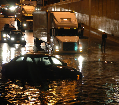
The bad news is that Seattle has experienced serious urban flooding events. Consider December 14, 2006, immediately before the Hanukah Eve windstorm. A band of very heavy rain (roughly 1 inch per hour) hit Seattle, with roads flooded and cars/trucks inundated (see image).
During the same event, a woman drowned in her basement in the Madison Valley of central Seattle.
Urban flooding also occurred over northeast Seattle near Thornton Creek during the winter storms of 1996/1997 and October 2003. Houses were destroyed and roads blocked. There are many other examples of major urban floods around the city I could describe.
A major flooding vulnerability for Seattle is engendered by the city's substantial terrain, which creates bowls and low spots for heavy rain to accumulate (see terrain map below). The Madison Valley is one of the most vulnerable areas, but there are others. New York City has less terrain for such a concentration of water.

- Seattle's urban flooding can usually be traced to one of three meteorological origins:
- Atmospheric Rivers that bring warm, moist air into the region from the southwest. The "Pineapple Express", with moisture streaming from near Hawaii is the most well known.
- Intense Pacific fronts, whose intense rainbands can stagnate over the city (what happened on December 14th before the Chanukah Eve Storm).
- Strong convective systems (thunderstorms), that although rare, can produce localized heavy rain.
The Good News
Although Seattle is known as a very wet place, we generally do not experience extreme short-period rainstorms as observed in much of the U.S. To illustrate this, here is a plot from a NOAA/NWS Atlas of extreme precipitation around the U.S. Specifically, the figure shows the 100-year one-hour rainfall around the country. To put it another way, considering rainfall falling over one hour, how much rain would fall in that hour during a once in a hundred-year rain event? You can expand on the figure by clicking on it.
For Seattle, as shown in the blow-up below, the 100-year one-hour event is approximately one inch, very close to what fell on December 14, 2006 in Seattle.

I went through the records of the rain gauge records over Seattle and could not find any exceeding 1 inch in an hour.
So Seattle does not get the intense, short-period rains observed over the eastern U.S., lessening our vulnerability to extreme, rapid urban flooding.
But why? The key reason is that we don't experience intense thunderstorms, embedded in tropical moisture, that remain in place long enough to produce extreme one-hour totals.
Extreme precipitation from thunderstorms requires very moist air, generally of tropical origin, great instability (the tendency for the air to connect), and something the focuses and maintains thunderstorms in one location.
These are EXACTLY the conditions that occurred in New York during the big event last week. Extremely moist and unstable air was pulled northward by the remnants of Hurricane Ida. A stationary front was set up by the storm, which created and focussed intense thunderstorms across the New York metro area (see radar imagery below). A "perfect storm" of a confluence of the necessary factors and one that is exceedingly rare.

Seattle simply can not get this level of intense, stationary thunderstorms for several reasons, including:
- Seattle is near cool water that discourages thunderstorms by lessening instability and results in less water vapor in the lower atmosphere (cool air can hold less water vapor than warm air).
- Seattle never experiences tropical storms because of the cool water
- Seattle does not have enough terrain to release intense, stationary thunderstorms, something that can happen near the Cascade foothills.
Will global warming change this situation? From the regional climate simulations we are running at the University of Washington (and these are gold standards of such work), there is no suggestion of increases in summer precipitation intensity in Seattle as the Earth warms.
The Bottom Line: Seattle can and will get heavy hourly precipitation, and we have our topographic vulnerabilities, but our extreme rain threat is clearly less than experienced in NY and the eastern U.S.
Final note: A key aspect of protecting Seattle citizens from heavy precipitation is to know what is happening and what will happen during the next few hours. The City of Seattle, with the University of Washington, developed one of the most advanced systems of this kind to do so, called Seattle RainWatch (see graphic).
Unfortunately, Seattle Public Utilities decided to no longer support RainWatch, leaving the city without an important tool for proactively dealing with heavy precipitation.

Post a Comment