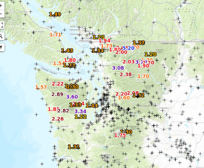
The dry part of the year is over. Done. Finished. Today and later this week, currents of moisture are impacting our region, bring substantial rain, particularly in the mountains. Over the 24 h ending at 7 PM Saturday, a number of locations has received several inches of rain, particularly over the SW side of the Olympics and north Cascades (the graphic below shows places getting more than 1.2 inches). A few locations have been drenched with 3-5 inches.

The radar image at 2:34 PM Saturday shows the precipitation explicitly. I had to quit my gardening tasks around this time....too wet.

This band is slowly moving southward and will be positioned south of Seattle on Sunday. Good for Seattle, bad for Portland and vicinity.
The UW WRF model run shows the 24h rainfall ending 5 AM Sunday, indicating 2-5 inches in places.

The forecast for the next 24hr (below) hits Portland and vicinity quite hard. Amazingly, tight east-west band. Very much the look of an atmospheric river.


The 72 hr total ending 5 PM Saturday are huge, reaching 5-10 inches near the Oregon/CA border.

A narrow tongue of moisture, originating in the tropics, called an atmospheric river, is associated with this wet bounty, as shown by the figure below (which shows the total amount of moisture in column of air, predicted for 5 PM Saturday). Blue and white are high values.

The radar image at 2:34 PM Saturday shows the precipitation explicitly. I had to quit my gardening tasks around this time....too wet.
This band is slowly moving southward and will be positioned south of Seattle on Sunday. Good for Seattle, bad for Portland and vicinity.
The UW WRF model run shows the 24h rainfall ending 5 AM Sunday, indicating 2-5 inches in places.

The forecast for the next 24hr (below) hits Portland and vicinity quite hard. Amazingly, tight east-west band. Very much the look of an atmospheric river.

But as interesting and impressive this event appears, a much more threatening situation will occur on Thursday, particularly over Oregon and northern CA. Here is the forecast atmospheric moisture forecast for 2 PM Thursday. Wow. First class atmospheric river (blue colors) all the way to the coast.

The 24h predicted totals ending 5 AM Friday are substantial from northern CA to southern BC, with "favored" black areas getting 2 to 5 inches.

The 72 hr total ending 5 PM Saturday are huge, reaching 5-10 inches near the Oregon/CA border.

So we are in store for an active period. October and November are primo atmospheric river months along the West Coast. The subtropics are still warm, so the moisture supply is large (warm air holds more water vapor) and the flow pattern gets more active, with deep troughs in the eastern Pacific drawing the moisture northward in filaments of high water vapor values. When such moisture is forced to rise by West Coast terrain....watch out. Very heavy precipitation is often the result. You better find your Goretex jacket.
Post a Comment