Normally, this blog is dedicated to West Coast meteorology, but I can't help myself today with Category 3 Hurricane Matthew now raking the Florida coast.
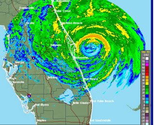
The radar image at 7:20 PM PDT Thursday from the NWS Melbourne radar is impressive, with the eye clearly evident just offshore and intense spiral rainbands circling around the system.

The HRRR model pressure analysis shows a deep low center just east of Florida, which huge pressure gradients (differences in pressure). The National Hurricane Center estimates max sustained winds of 130 mph and a central pressure of 939 hPa (mb). For comparison, the great Columbus Day Storm of 1962 only dropped to 955 hPa.
 This storm has savaged the Bahamas. Here are the gusts from a buoy SPGF1, which reached 91 knots (105 mph) before contact was lost.


Over Florida,the maximum gusts (last 24h), have reached into the 70s (mph) along the coast, so winds along the coast are barely making it to hurricane levels (sustained winds of 74 mph or more)


The radar image at 7:20 PM PDT Thursday from the NWS Melbourne radar is impressive, with the eye clearly evident just offshore and intense spiral rainbands circling around the system.
The HRRR model pressure analysis shows a deep low center just east of Florida, which huge pressure gradients (differences in pressure). The National Hurricane Center estimates max sustained winds of 130 mph and a central pressure of 939 hPa (mb). For comparison, the great Columbus Day Storm of 1962 only dropped to 955 hPa.

At 3 AM PDT Friday a very well developed eye was evident offshore, with the eye wall not quite reaching shore.
Over Florida,the maximum gusts (last 24h), have reached into the 70s (mph) along the coast, so winds along the coast are barely making it to hurricane levels (sustained winds of 74 mph or more)
This storm is taking a very unusual track--forecast to parallel the Atlantic coast before circling back on itself to hit Florida again as a weakened storm)--see predicted track below by the National Hurricane Center.
This track will result in heavy precipitation and hurricane-forced winds along a vast stretch of the Atlantic coast, with a storm surge north of the hurricane center.
But what about the forecasts? Meteorologists have a wide variety of forecast models to look at including:
- The European Center For Medium Range Weather Forecasting (ECMWF) model
- The UKMET Office model
- The U.S. GFS global model
- The U.S. high-resolution HWRF model
- ...and many more.
We can evaluate their skill in two ways:
- the accuracy of the position over time or track error
- the accuracy of the forecast of storm intensity (how deep the low center is, the maximum wind speed, etc.
Let's face it--the track forecast is the most important. Having a correct intensity forecast is not very useful if the storm is in the wrong place!
It turns out that there are consistent skill differences and one model is clearly superior for Hurricane track forecasting: the European Center model, with the UKMET right behind.
Here is a plot of the average position errors of various modeling systems for roughly the last week regarding Matthew (produced by an individual in NOAA). AVNO (green) is the US GFS, HWRF (light purple is HWRF), TECM (yellow) is ECMWF, and dark purple is UKMET. The errors are divided into length of forecast.
The results are STUNNING. UKMET and ECMWF are clearly the best. Next is GFS and HWRF is in the rear. U.S. loses big time.

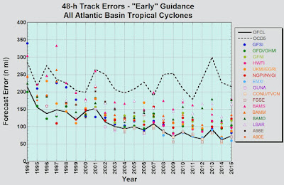
OK. This is one storm. The National Hurricane Center has done a similar analysis for many storms over the past several years, with similar results. This graph shows the change in 48h track errors for many modeling and forecasting systems for the Atlantic Basin. Track e have gotten much better in time for all systems--a real advance. But the best is clearly the European Center (light blue, with the GFS (dark blue) and HWRF (HWFI, reddish color) substantially behind.

HWRF tracks have been particularly problematic for Matthew and has held on to a clearly problematic forecast (with Matthew moving toward New England) far too long (see example below for forecast from October 5 at 11 AM PDT). HWRF heads to the NE (purple), while the GFS and official forecasts swing around in circle.

The inferiority of HWRF tracks is frequently observed, as is the superiority of the ECMWF tropical cyclone tracks. The latter reflects the excellence of the ECMWF global forecast compared to the US global model (GFS), something that I have talked about in this blog previously. My colleagues who are hurricane modeling experts tell me that HWRF has generally been a poor investment and should be terminated, a recommendation supported by objective information such as above. Instead, the U.S. needs to invest in improving its global modeling system, which is now in transition from the GFS to a new system called FV-3.
It is time for US weather modeling to become world class again.
And while national attention is directed toward Florida, the Northwest is getting its first blow of the season, with our winds comparable to much of Florida (see max gusts over the last 24 h below). Over 60 mph on the coast and NW Washington and even 73 mph at (where else?) Hurricane Ridge. Why does Weather Channel ignore us?
(PS: the National Hurricane Center's website WENT DOWN as the Hurricane approached the Florida Coast on Thursday evening. Not good)
Post a Comment