Very Heavy Rain and Flooding Coming to the Northwest

 For those thinking that a lamb-like spring was coming early, think again.

Very heavy rain and flooding will be arriving on Monday, the result of a potent atmospheric river.  Some locations in the lowlands will receive 2-4 inches on Monday, with twice that in "favored" mountain locations.

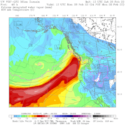
The origin of our wet future is a strong atmospheric river, a narrow region of large amounts of moisture, originating in the subtropics.  To illustrate, below is a plot of total moisture from the surface to the top of the atmosphere at 4 AM Monday.  As you might guess, the reddish colors are the largest amounts.

This atmospheric river starts north of Hawaii and heads northeastward right into our region.


But it is not only moisture that counts, but the rate at which moisture is approaching our region.  

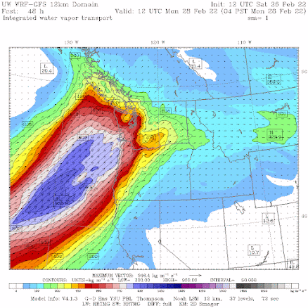
That is why meteorologists prefer to view integrated water vapor flux (IVT), an impressive-sounding term that actually means wind speed times water vapor.  Just drop the term "IVT" in your conversation and your friends and family will be impressed!  

Here is the plot of IVT for 4 AM Monday.  The blue values are very high.   A fast-moving river of moisture is heading straight for us.


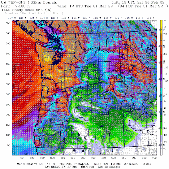
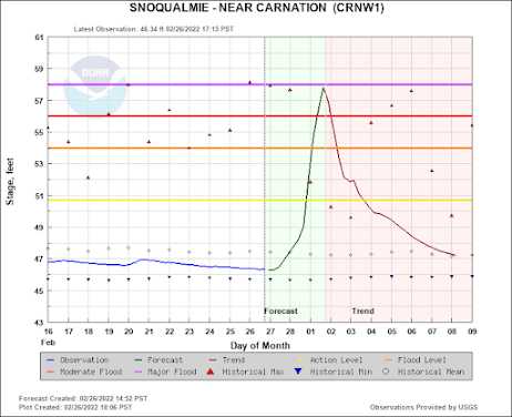
And when that river of moisture is forced upward by our regional terrain, an amazing amount of precipitation will be released.  Consider the latest University of Washington high-resolution precipitation forecast for the total accumulated precipitation through 4 AM Tuesday.  

Wow.  2-3 inches over Puget Sound and as much as 7-10 inches in the mountains.  Profound rain shadow from Sequim to northern Whidbey Island.


The highly skillful, but lower resolution, European Center model is going for a big event as well, with 3-4 inches in southern Puget Sound, and even Portland getting a food piece of the wet action.  The Olympics and coastal mountains get staggering amounts of precipitation.


For snow-lovers, this is not going to be the event you wanted, because atmospheric rivers are generally associated with warm air, and this is no different.  On Monday, the snow level will rise to 5000-6500 ft, so heavy rain will descend on the passes.

I would not go skiing on Monday.

With such massive amounts of rain, local rivers will rise rapidly, and flooding is expected on several.  Here is the latest river forecast from the NOAA/NWS River Forecast Center in Portland.  Minor to major flooding on several (orange and red dots), which is impressive considering that the rivers are starting out below normal after the recent dry weather.


The Snoqualmie River will get very, very close to major flooding (see a plot of river level below).  Expect some road closures.


But with all the problems, it will be good to get a good wetting for the region, with the rain thoroughly saturating the soils on both sides of the Cascades (good for agriculture) and pushing large volumes of water into regional reservoirs.  


Post a Comment

Previous Post Next Post

Iklan In-Feed (homepage)

" target="_blank">Responsive Advertisement